
ဝှာင်:Map of Ajanta Caves.svg

Size of this PNG preview of this SVG file: ၅၅၃ × ၆၀၀ pixels. အရာမသ္ဂုတ်သွာတ်လဝ်ဂမၠိုၚ်: ၂၂၁ × ၂၄၀ pixels | ၄၄၃ × ၄၈၀ pixels | ၇၀၈ × ၇၆၈ pixels | ၉၄၄ × ၁၀၂၄ pixels | ၁၈၈၉ × ၂၀၄၈ pixels | ၁၀၈၁ × ၁၁၇၂ pixels တၞဟ်။
ဝှာင် တမ်မူလ (SVG ဝှာင်, မိက်ကဵုကသပ် ၁၀၈၁ × ၁၁၇၂ pixels, ဇမၞော် ဝှာင်: ၁၄၄ KB)
သကေမ်
| ကဵုယၟု |
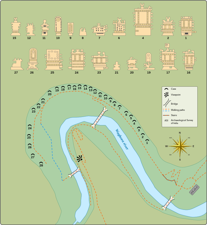
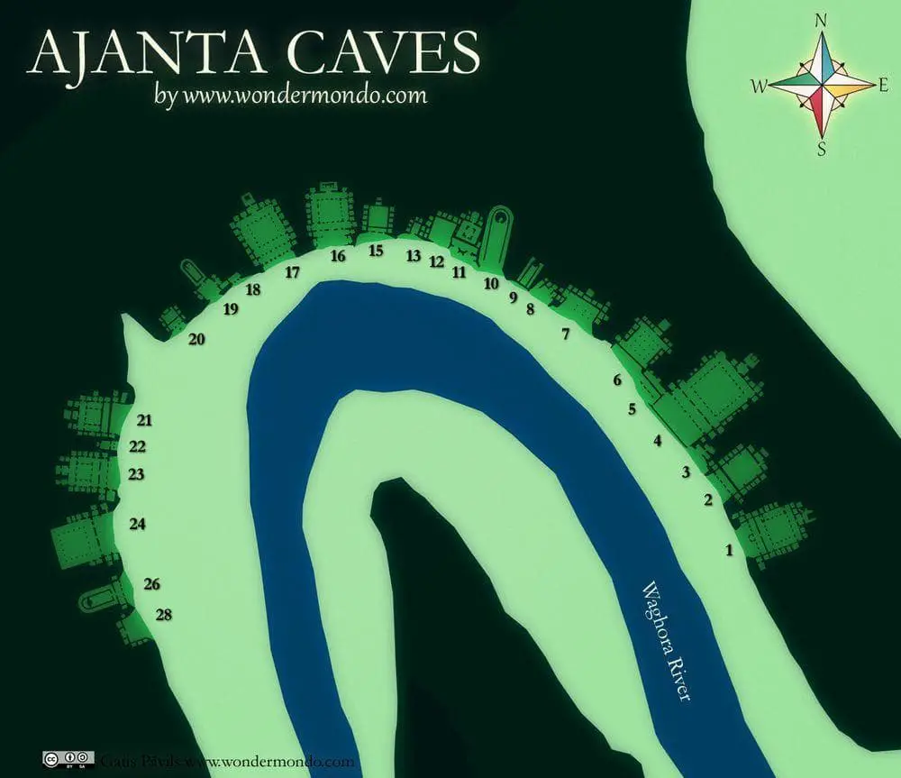
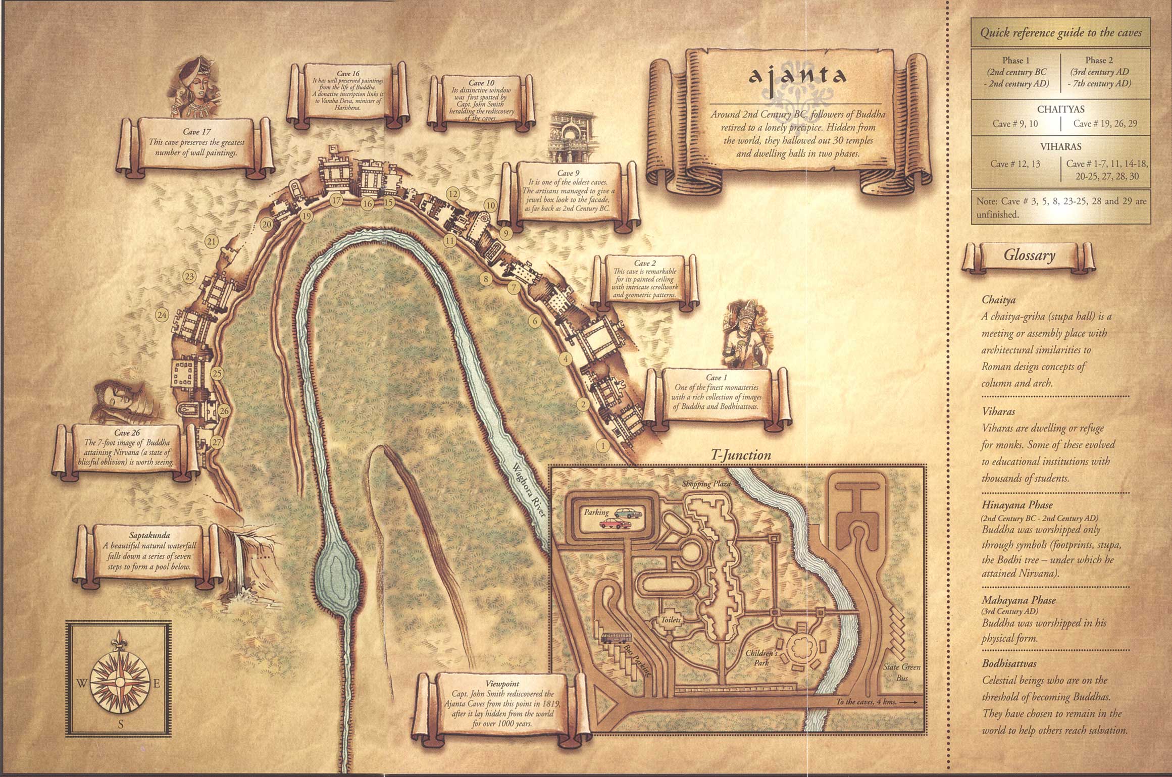
English: Maps and plans of the Ajanta Caves
|
||||||||||||||||||||
| စၟတ်တ္ၚဲ | |||||||||||||||||||||
| တမ်ရိုဟ် |
ကမၠောန် ဇကုအပိုင်
Information from:
|
||||||||||||||||||||
| ကဝိ | Goran_tek-en | ||||||||||||||||||||
| တင်မကဵုအခေါင် (ကလေင်သုင်စောဲ ဝှာင်ဏအ်) |
ဤဖိုင်သည် Creative Commons Attribution-Share Alike 4.0 နိုင်ငံတကာ လိုင်စင်အောက်တွင် လိုင်စင်သတ်မှတ်ထားပါသည်။ ဒဒှ်မစၟတ်သမ္တီကေတ်: Goran tek-en
|
||||||||||||||||||||
| SVG genesis | ဤ SVG ၏ ကုဒ်သည် ခိုင်လုံသည်။ This vector image was created with Inkscape. |
||||||||||||||||||||
.jpg)
| Object location | | View this and other nearby images on: OpenStreetMap |
|---|


ဝှာင် လၟေင်အပြံင်အလှာဲ
ဍဵု လတူ စၟတ်တ္ၚဲ/အခိင် မွဲမွဲ သွက်ဂွံ ထ္ၜးကဵု ဝှာင် မကတဵုဒှ်လဝ် ပ္ဍဲအခိင်ဂှ်၊၊
| စၟတ်တ္ၚဲ/အခိင် | ဗီုပြင်နမူနာ | ပမာဏ | ညးလွပ် | တင်ပသောင်ကလး | |
|---|---|---|---|---|---|
| လၟုဟ် | ၂၂:၂၂၊ ၆ ဒဳဇြေမ်ဗါ ၂၀၂၁ | | ၁၀၈၁ × ၁၁၇၂ (၁၄၄ KB) | Goran tek-en | ppi to 96, optimized |
| ၀၀:၁၆၊ ၆ ဨပြဳ ၂၀၁၅ |  | ၁၀၈၁ × ၁၁၇၂ (၃၆၇ KB) | Goran tek-en | User created page with UploadWizard |
ဝှာင် ဗီုဂွံစကာ
အရာမဆက်ဗက်ကၠုင် page links ကုဝှာင်ဏအ် ဂမၠိုင်ဂှ် -
ဝှာင် သွက်ဂွံသုင်စောဲ ဂလုပ်ဗဴ
ဗွဲသၟဝ်ဏအ်ဂှ် ဒှ်အရာ ဝဳကဳတၞဟ် မစကာလဝ် ဝှာင်ဏအ်၊၊
- ဗီုစကာ ပ္ဍဲ ca.wikipedia.org
- ဗီုစကာ ပ္ဍဲ en.wikipedia.org
- ဗီုစကာ ပ္ဍဲ gom.wikipedia.org
- ဗီုစကာ ပ္ဍဲ ml.wikipedia.org
- ဗီုစကာ ပ္ဍဲ mr.wikipedia.org
- ဗီုစကာ ပ္ဍဲ mt.wikipedia.org
- ဗီုစကာ ပ္ဍဲ or.wikipedia.org
- ဗီုစကာ ပ္ဍဲ sl.wikipedia.org
- ဗီုစကာ ပ္ဍဲ sq.wikipedia.org
- ဗီုစကာ ပ္ဍဲ te.wikipedia.org
- ဗီုစကာ ပ္ဍဲ uk.wikipedia.org