
ဝှာင်:Map of current Interstates.svg

Size of this PNG preview of this SVG file: ၆၈၉ × ၄၃၂ pixels. အရာမသ္ဂုတ်သွာတ်လဝ်ဂမၠိုၚ်: ၃၂၀ × ၂၀၁ pixels | ၆၄၀ × ၄၀၁ pixels | ၁၀၂၄ × ၆၄၂ pixels | ၁၂၈၀ × ၈၀၃ pixels | ၂၅၆၀ × ၁၆၀၅ pixels တၞဟ်။
ဝှာင် တမ်မူလ (SVG ဝှာင်, မိက်ကဵုကသပ် ၆၈၉ × ၄၃၂ pixels, ဇမၞော် ဝှာင်: ၅၁၈ KB)

|
This file requires updating because: Multiple Interstates and future Interstate are Missing In doing so, you could add a timestamp to the file.
|
သကေမ်
| ကဵုယၟု |
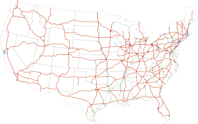
Labels:
One or Two-digit interstates (dark orange line)
Selected three-digit interstates (blue line)
Selected planned interstates (green dashed line) |
| စၟတ်တ္ၚဲ | |
| တမ်ရိုဟ် | National Atlas |
| ကဝိ | SPUI |
မသ္ဂုတ်သွာတ်လာင်ဇြေန်
| This work has been released into the public domain by its author, SPUI. This applies worldwide. In some countries this may not be legally possible; if so: |
| Annotations | This image is annotated: View the annotations at Commons |
ဝှာင် လၟေင်အပြံင်အလှာဲ
ဍဵု လတူ စၟတ်တ္ၚဲ/အခိင် မွဲမွဲ သွက်ဂွံ ထ္ၜးကဵု ဝှာင် မကတဵုဒှ်လဝ် ပ္ဍဲအခိင်ဂှ်၊၊
| စၟတ်တ္ၚဲ/အခိင် | ဗီုပြင်နမူနာ | ပမာဏ | ညးလွပ် | တင်ပသောင်ကလး | |
|---|---|---|---|---|---|
| လၟုဟ် | ၁၇:၄၉၊ ၁၃ ဖေဖဝ်ဝါရဳ ၂၀၁၃ | | ၆၈၉ × ၄၃၂ (၅၁၈ KB) | Scott5114 | Add I-49 in Missouri |
| ၁၃:၀၉၊ ၁၁ ဇာန်နဝါရဳ ၂၀၁၃ |  | ၆၈၉ × ၄၃၂ (၅၁၉ KB) | Agricolae | add I-376 rebranding north to I-80, planned I-99 from I-80 to I-86 | |
| ၁၃:၅၇၊ ၂ ဂျူလာင် ၂၀၁၁ |  | ၆၈၉ × ၄၃၂ (၄၈၅ KB) | Jkirkuslamont | Changed hues to improve legibility for the colour blind | |
| ၁၁:၀၆၊ ၁၀ ဇာန်နဝါရဳ ၂၀၁၀ |  | ၆၈၉ × ၄၃၂ (၇၅၄ KB) | Techman224 | Made three-dight Interstates near Atlanta, Georgia blue | |
| ၀၄:၀၂၊ ၂၄ ဒဳဇြေမ်ဗါ ၂၀၀၉ |  | ၆၈၉ × ၄၃၂ (၇၅၄ KB) | Clorox | added I69 | |
| ၁၂:၄၂၊ ၂၉ ဖေဖဝ်ဝါရဳ ၂၀၀၈ |  | ၆၈၉ × ၄၃၂ (၇၄၄ KB) | Alex43223 | Updated a couple highways | |
| ၀၉:၀၈၊ ၂၂ ဂျောန် ၂၀၀၇ |  | ၆၈၉ × ၄၃၂ (၆၈၇ KB) | Fran Rogers | Reverted to earlier revision | |
| ၀၉:၀၇၊ ၂၂ ဂျောန် ၂၀၀၇ |  | ၆၈၉ × ၄၃၂ (၆၈၇ KB) | Fran Rogers | {{spuimap}} Map of the present Interstate Highway System. Base map is [http://www.nationalatlas.gov/printable/images/pdf/reference/genref.pdf] (public domain US Federal Government). *Purple: two-digit *Blue: selected three-digit *Green: selected future ro | |
| ၂၂:၃၇၊ ၁၃ ဂျူလာင် ၂၀၀၆ |  | ၆၈၉ × ၄၃၂ (၆၈၇ KB) | SPUI~commonswiki | {{spuimap}} |
ဝှာင် ဗီုဂွံစကာ
အရာမဆက်ဗက်ကၠုင် page links ကုဝှာင်ဏအ် ဂမၠိုင်ဂှ် -
ဝှာင် သွက်ဂွံသုင်စောဲ ဂလုပ်ဗဴ
ဗွဲသၟဝ်ဏအ်ဂှ် ဒှ်အရာ ဝဳကဳတၞဟ် မစကာလဝ် ဝှာင်ဏအ်၊၊
- ဗီုစကာ ပ္ဍဲ an.wikipedia.org
- ဗီုစကာ ပ္ဍဲ ar.wikipedia.org
- ဗီုစကာ ပ္ဍဲ ast.wikipedia.org
- ဗီုစကာ ပ္ဍဲ az.wikipedia.org
- ဗီုစကာ ပ္ဍဲ bg.wikipedia.org
- ဗီုစကာ ပ္ဍဲ bs.wikipedia.org
- ဗီုစကာ ပ္ဍဲ ca.wikipedia.org
- ဗီုစကာ ပ္ဍဲ da.wikipedia.org
- ဗီုစကာ ပ္ဍဲ de.wikipedia.org
- ဗီုစကာ ပ္ဍဲ en.wikipedia.org
- Economy of the United States
- Transportation in the United States
- List of gaps in Interstate Highways
- List of auxiliary Interstate Highways
- Controlled-access highway
- List of business routes of the Interstate Highway System
- User:Master son/US Roads
- User:Master son/US Roads/MTF
- Driving in the United States
- Trucking industry in the United States
- 1956 in the United States
- List of transport megaprojects
- User:Stephen100002/sandbox
- User:Vigneshdm1990/sandbox
- User:44Nifty/sandbox
- User:XanUltra
- Transportation policy of the United States
- Talk:United States/Archive 102
- Portal:Transport/Highway media
- Wikipedia talk:External links/Archive 42
- Wikipedia:Village pump (technical)/Archive 208
- ဗီုစကာ ပ္ဍဲ en.wikibooks.org
- ဗီုစကာ ပ္ဍဲ eo.wikipedia.org
- ဗီုစကာ ပ္ဍဲ es.wikipedia.org
- ဗီုစကာ ပ္ဍဲ et.wikipedia.org
- ဗီုစကာ ပ္ဍဲ eu.wikipedia.org
- ဗီုစကာ ပ္ဍဲ fa.wikipedia.org
- ဗီုစကာ ပ္ဍဲ fi.wikipedia.org
ဗဵု more global usage ဝှာင်ဏအ်၊၊