
ဝှာင်:Morocco relief location map.jpg

ဇမၞော် နမူနာ ဏအ် - ၇၃၇ × ၆၀၀ pixels အရာမသ္ဂုတ်သွာတ်လဝ်ဂမၠိုၚ်: ၂၉၅ × ၂၄၀ pixels | ၅၉၀ × ၄၈၀ pixels | ၉၄၄ × ၇၆၈ pixels | ၁၂၂၃ × ၉၉၅ pixels တၞဟ်။
ဝှာင် တမ်မူလ (၁၂၂၃ × ၉၉၅ pixels, file size: ၂၆၅ KB, MIME type: image/jpeg)
သကေမ်
| ကဵုယၟု |
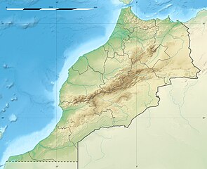
English: Blank physical map of Morocco, for geo-location purposes.
Français : Carte physique vierge du Maroc, destinée à la géolocalisation. Scale: 1:4,000,000 (precision: 1,000 m)
Geographic limits of the map:
|
||
| စၟတ်တ္ၚဲ | 2009-11, updated 2017-02 | ||
| တမ်ရိုဟ် |
ကမၠောန် ဇကုအပိုင်
|
||
| ကဝိ | Eric Gaba (Sting - fr:Sting) | ||
| တင်မကဵုအခေါင် (ကလေင်သုင်စောဲ ဝှာင်ဏအ်) |
|
||
| အခြား ဗားရှင်းများ |
|

| Camera location | | View this and other nearby images on: OpenStreetMap |
|---|
မသ္ဂုတ်သွာတ်လာင်ဇြေန်
ကျွန်ုပ်၊ ဤလုပ်ဆောင်ချက်၏ မူပိုင်ခွင့်ပိုင်ရှင်အနေဖြင့် ဤနေရာမှ အောက်ပါလိုင်စင်များအောက်တွင် ထုတ်လွှင့်ပါသည်:
ဝှာင်ဏအ်ဂှ် စၟတ်သမ္တီလဝ် နကဵုလာင်ဇြေန် Creative Commons Attribution-Share Alike 3.0 Unported ရ၊၊
- မၞးဂှ် ဗွဲမဗၠးၜး -
- သွက်ဂွံ ပါ်ပရအ် – သွက်ဂွံ စၠောအ်ပပ်ပဳ၊ တြးပတိတ်၊ ဗလး ကမၠောန်
- သွက်ဂွံ ပကောံနှဴ – သွက်ဂွံ ပလေဝ်ပညဳ ကမၠောန်
- နကဵု တင်မသ္ဒးဒ္ဂေတ်ဗက် ဗွဲသၟဝ်ဏအ်ဂှ်
- တင်မစှ်ေစိုတ် – မၞး သ္ဒးဒ္ဂေတ်ဗက် သၞောတ်ဝ် မဖျေဟ်လဝ် စပ်ကဵု အစာချူလိက် ဟွံသေင်မ္ဂး တၠမူတအ်ရောင်၊၊ (ဆဂး နကဵုနဲလဵု အကာဲအရာ ဗီုလဵုလေဝ် ဟွံကဵုကသပ် ဟွံထံက်ဂလာန် ကုမၞး ပ္ဍဲအရာမစကာ ဒြပ်ညးတၞဟ်တအ်ရောင်)။
- ပါ်ပရအ် အရာမတုပ်သၟဟ် – ယဝ်ရ မၞး ပလေဝ်၊ ပြံင်လှာဲ ဟွံသေင်မ္ဂး ထပ်ခၞံဗဒှ်တၟိမ္ဂး အရာကမၠောန်တအ် သီုဖအိုတ်ဂှ် သ္ဒးပရးပတိတ် နကဵုသၟဝ် မတုပ် ဟွံသေင်မ္ဂး မသၟဟ် ကုလာင်ဇြေန် ကမၠောန်တြေံဂှ် ဟေင်ရ၊၊

|
လိက်တအ်ဂှ် သၠးကဵုလဝ် အခေါင် သွက်ဂွံ စၠောအ်ကပ်ပဳ၊ ပရး ကီု သီုကဵု ပလေဝ်ပခိုဟ်ပတိုန် အတိုင်သၞောတ်ဝ် GNU Free Documentation License, တုဲ မူ ၁.၂ ဟွံသေင်မ္ဂး မူတြေံနူဂှ် မတြးပတိတ် နကဵု သၞောတ်ဝ်လာင်ဇြေန် Free Software Foundation; with no Invariant Sections, no Front-Cover Texts, and no Back-Cover Texts. A copy of the license is included in the section entitled GNU Free Documentation License. |
လာင်ဇြေန် မၞး မၞုံပၟိက်ဂှ် မၞးရုဲစှ်ကေတ် မာန်ရ၊၊
ဝှာင် လၟေင်အပြံင်အလှာဲ
ဍဵု လတူ စၟတ်တ္ၚဲ/အခိင် မွဲမွဲ သွက်ဂွံ ထ္ၜးကဵု ဝှာင် မကတဵုဒှ်လဝ် ပ္ဍဲအခိင်ဂှ်၊၊
| စၟတ်တ္ၚဲ/အခိင် | ဗီုပြင်နမူနာ | ပမာဏ | ညးလွပ် | တင်ပသောင်ကလး | |
|---|---|---|---|---|---|
| လၟုဟ် | ၀၃:၂၅၊ ၁၁ ဖေဖဝ်ဝါရဳ ၂၀၁၇ | | ၁၂၂၃ × ၉၉၅ (၂၆၅ KB) | Sting | Updated regions borders as since 2015 |
| ၁၉:၄၁၊ ၁၉ ဂျူလာင် ၂၀၁၀ |  | ၁၂၂၃ × ၉၉၅ (၂၃၄ KB) | Sting | Color profile | |
| ၀၃:၀၁၊ ၂၂ နဝ်ဝေမ်ဗါ ၂၀၀၉ |  | ၁၂၂၃ × ၉၉၅ (၂၄၀ KB) | Sting | Putting back the southern dotted boundary (regarding Western Sahara's location map) | |
| ၀၇:၅၃၊ ၂၁ နဝ်ဝေမ်ဗါ ၂၀၀၉ |  | ၁၂၂၃ × ၉၉၅ (၂၃၉ KB) | Sting | Drawback for one "correction" | |
| ၀၇:၄၀၊ ၂၁ နဝ်ဝေမ်ဗါ ၂၀၀၉ |  | ၁၂၂၃ × ၉၉၅ (၂၄၀ KB) | Sting | Several little corrections | |
| ၀၆:၃၉၊ ၂၁ နဝ်ဝေမ်ဗါ ၂၀၀၉ |  | ၁၂၂၃ × ၉၉၅ (၂၄၁ KB) | Sting | == {{int:filedesc}} == {{Location|31|46|30|N|7|04|30|W|scale:5000000}} <br/> {{Information |Description={{en|Blank physical map of Morocco, for geo-location purposes.}} {{fr|Carte physique vierge du Maroc, destinée à la gé |
ဝှာင် ဗီုဂွံစကာ
အရာမဆက်ဗက်ကၠုင် 2 pages link ကုဝှာင်ဏအ် ဂမၠိုင်ဂှ် -
ဝှာင် သွက်ဂွံသုင်စောဲ ဂလုပ်ဗဴ
ဗွဲသၟဝ်ဏအ်ဂှ် ဒှ်အရာ ဝဳကဳတၞဟ် မစကာလဝ် ဝှာင်ဏအ်၊၊
- ဗီုစကာ ပ္ဍဲ af.wikipedia.org
- ဗီုစကာ ပ္ဍဲ ar.wikipedia.org
- ဗီုစကာ ပ္ဍဲ ast.wikipedia.org
- ဗီုစကာ ပ္ဍဲ azb.wikipedia.org
- ဗီုစကာ ပ္ဍဲ az.wikipedia.org
- ဗီုစကာ ပ္ဍဲ ba.wikipedia.org
- ဗီုစကာ ပ္ဍဲ be.wikipedia.org
- ဗီုစကာ ပ္ဍဲ bg.wikipedia.org
ဗဵု more global usage ဝှာင်ဏအ်၊၊