
ဝှာင်:1997 Red River Flood Grand Forks.jpg
ဇမၞော် နမူနာ ဏအ် - ၇၅၇ × ၆၀၀ pixels အရာမသ္ဂုတ်သွာတ်လဝ်ဂမၠိုၚ်: ၃၀၃ × ၂၄၀ pixels | ၆၀၆ × ၄၈၀ pixels | ၉၇၀ × ၇၆၈ pixels | ၁၂၈၀ × ၁၀၁၄ pixels | ၁၅၀၀ × ၁၁၈၈ pixels တၞဟ်။
ဝှာင် တမ်မူလ (၁၅၀၀ × ၁၁၈၈ pixels, file size: ၈၁၂ KB, MIME type: image/jpeg)
| ကဵုယၟု |
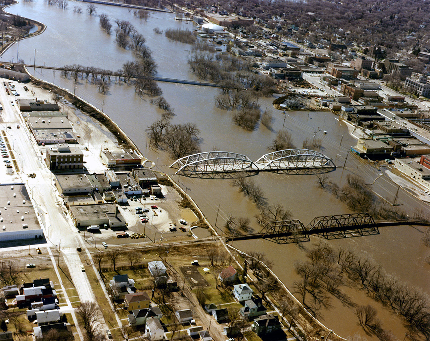
English: The Red River in flood in April or May 1997 in Grand Forks, North Dakota and East Grand Forks, Minnesota. |
|||
| စၟတ်တ္ၚဲ | ||||
| တမ်ရိုဟ် |
U.S. Army Corps of Engineers Digital Visual Library Image page Image description page Digital Visual Library home page |
|||
| ကဝိ | Ken Gardner, U.S. Army Corps of Engineers | |||
| တင်မကဵုအခေါင် (ကလေင်သုင်စောဲ ဝှာင်ဏအ်) |
|
|||
| Location | Grand Forks, North Dakota and East Grand Forks, Minnesota, USA |
| Camera location | | View this and other nearby images on: OpenStreetMap |
|---|
ဝှာင် လၟေင်အပြံင်အလှာဲ
ဍဵု လတူ စၟတ်တ္ၚဲ/အခိင် မွဲမွဲ သွက်ဂွံ ထ္ၜးကဵု ဝှာင် မကတဵုဒှ်လဝ် ပ္ဍဲအခိင်ဂှ်၊၊
| စၟတ်တ္ၚဲ/အခိင် | ဗီုပြင်နမူနာ | ပမာဏ | ညးလွပ် | တင်ပသောင်ကလး | |
|---|---|---|---|---|---|
| လၟုဟ် | ၀၉:၅၁၊ ၅ ဒဳဇြေမ်ဗါ ၂၀၁၆ | | ၁၅၀၀ × ၁၁၈၈ (၈၁၂ KB) | HopsonRoad | Improve color balance. |
| ၀၁:၂၂၊ ၈ ဨပြဳ ၂၀၀၇ |  | ၁၅၀၀ × ၁၁၈၈ (၇၉၅ KB) | DanMS | {{Information | Description = {{en|The Red River in flood in April or May of 1997 in Grand Forks, North Dakota and East Grand Forks, Minnesota.}} | Source = U.S. Army Corps of Engineers Digital Visual Library<br />[http://images.usace.army.mil/ |
ဝှာင် ဗီုဂွံစကာ
မုက်လိက် မရပ်စပ် ဝှာင်ဏအ် ဟွံမဲ၊၊
ဝှာင် သွက်ဂွံသုင်စောဲ ဂလုပ်ဗဴ
ဗွဲသၟဝ်ဏအ်ဂှ် ဒှ်အရာ ဝဳကဳတၞဟ် မစကာလဝ် ဝှာင်ဏအ်၊၊
- ဗီုစကာ ပ္ဍဲ en.wikipedia.org
- ဗီုစကာ ပ္ဍဲ es.wikipedia.org
- ဗီုစကာ ပ္ဍဲ fo.wikipedia.org
- ဗီုစကာ ပ္ဍဲ fr.wikipedia.org
- ဗီုစကာ ပ္ဍဲ ja.wikipedia.org
- ဗီုစကာ ပ္ဍဲ ko.wikipedia.org
- ဗီုစကာ ပ္ဍဲ oc.wikipedia.org