
ဝှာင်:Americas Köppen Map.png

ဇမၞော် နမူနာ ဏအ် - ၄၈၃ × ၅၉၉ pixels အရာမသ္ဂုတ်သွာတ်လဝ်ဂမၠိုၚ်: ၁၉၃ × ၂၄၀ pixels | ၃၈၇ × ၄၈၀ pixels | ၆၁၉ × ၇၆၈ pixels | ၁၀၉၆ × ၁၃၆၀ pixels တၞဟ်။
ဝှာင် တမ်မူလ (၁၀၉၆ × ၁၃၆၀ pixels, file size: ၅၂၀ KB, MIME type: image/png)
သကေမ်
| ကဵုယၟု |
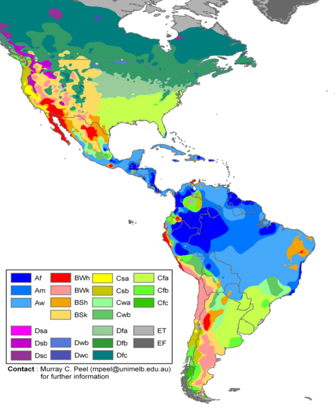
English: Edited Americas map of the Köppen-Geiger climate classification. The original was a world map JPG file which was converted to a smaller PNG file, without extra modifications, by Jeroen. The PNG file was further modified by WolfmanSF as follows: the map was cropped to reduce it to South America and most of North America; climate zone Dfa was changed to web color 99CC99, and climate zone Dfb was changed to web color 339933 (both shades of green); the color modifications to climate zones of temperate North America were intended to make the colors of tropical climate zones more distinctive, for use in articles on the Great American Interchange. The legend was rearranged, and climate zones Cwc, Dsd, Dwa, Dwd and Dfd were removed from the legend because they do not appear on this map. |
| စၟတ်တ္ၚဲ | |
| တမ်ရိုဟ် | Hydrology and Earth System Sciences: "Updated world map of the Köppen-Geiger climate classification" (Supplement) |
| ကဝိ |
Peel, M. C., Finlayson, B. L., and McMahon, T. A. (University of Melbourne) Citation: Peel, M. C., Finlayson, B. L., and McMahon, T. A.: Updated world map of the Köppen-Geiger climate classification, Hydrol. Earth Syst. Sci., 11, 1633-1644, 2007. |
| အခြား ဗားရှင်းများ |
|

မသ္ဂုတ်သွာတ်လာင်ဇြေန်
ဤဖိုင်သည် Creative Commons Attribution-Share Alike 2.5 Generic လိုင်စင်အောက်တွင် လိုင်စင်သတ်မှတ်ထားပါသည်။
- မၞးဂှ် ဗွဲမဗၠးၜး -
- သွက်ဂွံ ပါ်ပရအ် – သွက်ဂွံ စၠောအ်ပပ်ပဳ၊ တြးပတိတ်၊ ဗလး ကမၠောန်
- သွက်ဂွံ ပကောံနှဴ – သွက်ဂွံ ပလေဝ်ပညဳ ကမၠောန်
- နကဵု တင်မသ္ဒးဒ္ဂေတ်ဗက် ဗွဲသၟဝ်ဏအ်ဂှ်
- တင်မစှ်ေစိုတ် – မၞး သ္ဒးဒ္ဂေတ်ဗက် သၞောတ်ဝ် မဖျေဟ်လဝ် စပ်ကဵု အစာချူလိက် ဟွံသေင်မ္ဂး တၠမူတအ်ရောင်၊၊ (ဆဂး နကဵုနဲလဵု အကာဲအရာ ဗီုလဵုလေဝ် ဟွံကဵုကသပ် ဟွံထံက်ဂလာန် ကုမၞး ပ္ဍဲအရာမစကာ ဒြပ်ညးတၞဟ်တအ်ရောင်)။
- ပါ်ပရအ် အရာမတုပ်သၟဟ် – ယဝ်ရ မၞး ပလေဝ်၊ ပြံင်လှာဲ ဟွံသေင်မ္ဂး ထပ်ခၞံဗဒှ်တၟိမ္ဂး အရာကမၠောန်တအ် သီုဖအိုတ်ဂှ် သ္ဒးပရးပတိတ် နကဵုသၟဝ် မတုပ် ဟွံသေင်မ္ဂး မသၟဟ် ကုလာင်ဇြေန် ကမၠောန်တြေံဂှ် ဟေင်ရ၊၊
ဝှာင် လၟေင်အပြံင်အလှာဲ
ဍဵု လတူ စၟတ်တ္ၚဲ/အခိင် မွဲမွဲ သွက်ဂွံ ထ္ၜးကဵု ဝှာင် မကတဵုဒှ်လဝ် ပ္ဍဲအခိင်ဂှ်၊၊
| စၟတ်တ္ၚဲ/အခိင် | ဗီုပြင်နမူနာ | ပမာဏ | ညးလွပ် | တင်ပသောင်ကလး | |
|---|---|---|---|---|---|
| လၟုဟ် | ၀၁:၅၀၊ ၂၁ ဖေဖဝ်ဝါရဳ ၂၀၁၈ | | ၁၀၉၆ × ၁၃၆၀ (၅၂၀ KB) | Maphobbyist | The Costa Rican Central Valley has a dry winter oceanic climate (Köppen classification: Cwb). |
| ၀၆:၄၉၊ ၈ ဖေဖဝ်ဝါရဳ ၂၀၁၈ |  | ၁၀၉၆ × ၁၃၆၀ (၄၃၃ KB) | WolfmanSF | Reverted to version as of 10:48, 27 December 2008 (UTC) - the northernmost areas aren't of much interest for the purposes of the Great American Interchange article which uses this image | |
| ၀၄:၀၀၊ ၈ ဖေဖဝ်ဝါရဳ ၂၀၁၈ |  | ၁၈၆၀ × ၁၅၉၃ (၅၂၆ KB) | Maphobbyist | Included Alaska, Northern Canada and Greenland which were omitted. | |
| ၁၇:၁၈၊ ၂၇ ဒဳဇြေမ်ဗါ ၂၀၀၈ |  | ၁၀၉၆ × ၁၃၆၀ (၄၃၃ KB) | WolfmanSF | {{Information |Description= |Source= |Date= |Author= |Permission= |other_versions= }} | |
| ၀၄:၁၆၊ ၂၂ ဒဳဇြေမ်ဗါ ၂၀၀၈ |  | ၁၀၉၆ × ၁၃၆၀ (၄၃၉ KB) | WolfmanSF | rotate legend to make lettering horizontal; remove boxes for unused climate zones | |
| ၁၁:၅၁၊ ၅ မေ ၂၀၀၈ |  | ၁၀၉၆ × ၁၃၆၀ (၄၂၈ KB) | WolfmanSF | {{Information |Description=Updated world map of the Köppen-Geiger climate classification. |Source=[http://www.hydrol-earth-syst-sci.net/11/1633/2007/hess-11-1633-2007.html Hydrology and Earth System Sciences: "Updated world map of the Köppen-Geiger clim |
ဝှာင် ဗီုဂွံစကာ
မုက်လိက် မရပ်စပ် ဝှာင်ဏအ် ဟွံမဲ၊၊
ဝှာင် သွက်ဂွံသုင်စောဲ ဂလုပ်ဗဴ
ဗွဲသၟဝ်ဏအ်ဂှ် ဒှ်အရာ ဝဳကဳတၞဟ် မစကာလဝ် ဝှာင်ဏအ်၊၊
- ဗီုစကာ ပ္ဍဲ az.wikipedia.org
- ဗီုစကာ ပ္ဍဲ bg.wikipedia.org
- ဗီုစကာ ပ္ဍဲ en.wikipedia.org
- ဗီုစကာ ပ္ဍဲ es.wikipedia.org
- ဗီုစကာ ပ္ဍဲ fr.wikipedia.org
- ဗီုစကာ ပ္ဍဲ he.wikipedia.org
- ဗီုစကာ ပ္ဍဲ nl.wikipedia.org