
ဝှာင်:Balkan topo en.jpg

ဇမၞော် နမူနာ ဏအ် - ၆၅၇ × ၆၀၀ pixels အရာမသ္ဂုတ်သွာတ်လဝ်ဂမၠိုၚ်: ၂၆၃ × ၂၄၀ pixels | ၅၂၆ × ၄၈၀ pixels | ၈၄၀ × ၇၆၇ pixels တၞဟ်။
ဝှာင် တမ်မူလ (၈၄၀ × ၇၆၇ pixels, file size: ၆၃၈ KB, MIME type: image/jpeg)
သကေမ်
| ကဵုယၟု |
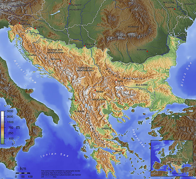
English: The topography of the Balkan Peninsula, as defined by the Danube-Sava-Kupa line. |
||||||||||
| စၟတ်တ္ၚဲ | 2006, before Serbia and Montenegro was split into two separate states. | ||||||||||
| တမ်ရိုဟ် | ကမၠောန် ဇကုအပိုင် | ||||||||||
| ကဝိ | Captain Blood~commonswiki | ||||||||||
| တင်မကဵုအခေါင် (ကလေင်သုင်စောဲ ဝှာင်ဏအ်) |
|
||||||||||
| အခြား ဗားရှင်းများ |
|

ဝှာင် လၟေင်အပြံင်အလှာဲ
ဍဵု လတူ စၟတ်တ္ၚဲ/အခိင် မွဲမွဲ သွက်ဂွံ ထ္ၜးကဵု ဝှာင် မကတဵုဒှ်လဝ် ပ္ဍဲအခိင်ဂှ်၊၊
| စၟတ်တ္ၚဲ/အခိင် | ဗီုပြင်နမူနာ | ပမာဏ | ညးလွပ် | တင်ပသောင်ကလး | |
|---|---|---|---|---|---|
| လၟုဟ် | ၁၅:၄၅၊ ၁၄ နဝ်ဝေမ်ဗါ ၂၀၁၅ | | ၈၄၀ × ၇၆၇ (၆၃၈ KB) | SilentResident | Corrected mistake in which the Aegean and Ionian islands were marked as part of the Balkan topography. |
| ၀၄:၂၃၊ ၂ ဖေဖဝ်ဝါရဳ ၂၀၁၂ |  | ၁၃၈၄ × ၁၂၆၄ (၇၂၆ KB) | Ras67 | losslessly cropped with Jpegcrop | |
| ၀၄:၂၂၊ ၂ ဖေဖဝ်ဝါရဳ ၂၀၁၂ |  | ၁၃၈၄ × ၁၂၆၄ (၇၂၆ KB) | Ras67 | losslessly cropped with Jpegcrop | |
| ၀၀:၀၄၊ ၁၅ ဨပြဳ ၂၀၀၆ |  | ၁၄၀၀ × ၁၂၇၈ (၇၄၈ KB) | Captain Blood~commonswiki | labels | |
| ၂၃:၅၂၊ ၂ ဨပြဳ ၂၀၀၆ |  | ၁၄၀၀ × ၁၂၇၈ (၇၄၈ KB) | Captain Blood~commonswiki | Una border | |
| ၀၂:၀၈၊ ၂ ဨပြဳ ၂၀၀၆ |  | ၁၄၀၀ × ၁၂၇၈ (၇၄၁ KB) | Captain Blood~commonswiki | {{Bild-GFDL-GMT}} |
ဝှာင် ဗီုဂွံစကာ
မုက်လိက် မရပ်စပ် ဝှာင်ဏအ် ဟွံမဲ၊၊
ဝှာင် သွက်ဂွံသုင်စောဲ ဂလုပ်ဗဴ
ဗွဲသၟဝ်ဏအ်ဂှ် ဒှ်အရာ ဝဳကဳတၞဟ် မစကာလဝ် ဝှာင်ဏအ်၊၊
- ဗီုစကာ ပ္ဍဲ af.wikipedia.org
- ဗီုစကာ ပ္ဍဲ ang.wikipedia.org
- ဗီုစကာ ပ္ဍဲ an.wikipedia.org
- ဗီုစကာ ပ္ဍဲ ar.wikipedia.org
- ဗီုစကာ ပ္ဍဲ arz.wikipedia.org
- ဗီုစကာ ပ္ဍဲ ast.wikipedia.org
- ဗီုစကာ ပ္ဍဲ be-tarask.wikipedia.org
- ဗီုစကာ ပ္ဍဲ bg.wikipedia.org
- ဗီုစကာ ပ္ဍဲ bn.wikipedia.org
- ဗီုစကာ ပ္ဍဲ bs.wikipedia.org
- ဗီုစကာ ပ္ဍဲ ca.wikipedia.org
- ဗီုစကာ ပ္ဍဲ ckb.wikipedia.org
ဗဵု more global usage ဝှာင်ဏအ်၊၊