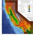
ဝှာင်:California Topography and Geomorphic.gif

အခြားဘာသာစကားများဖြင့် စာမျက်နှာအကြောင်းအရာများကို ပံ့ပိုးမထားပါ။
နူ ဝဳကဳပဳဒဳယာ

ဝှာင် တမ်မူလ(၁၁၁၇ × ၁၂၀၀ pixels, file size: ၃၃၆ KB, MIME type: image/gif, looped, ၀.၁ s)

ဝှာင်ဏအ် ဒှ်ဝှာင် နူကဵု ဝီကီမီဒီယာ ကွန်မွန်းစ် တုဲ မဒှ်ဝှာင် မသုင်စောဲလဝ် နကဵုပရဝ်ဂျေတ် တၞဟ်လေဝ် ဒှ်မာန်ရ၊၊ အရာမလဴထ္ၜး ပ္ဍဲဝှာင်တအ်ဂှ် မုက်လိက် မလဴထ္ၜး ဝှာင် ထ္ၜးကဵုလဝ် အတိုင်ဗွဲသၟဝ်ဝွံရ၊၊

သကေမ်

ကဵုယၟု A map of California showing topography and geomorphic provinces.
စၟတ်တ္ၚဲ (UTC)
တမ်ရိုဟ် This file was derived from: California Topography-MEDIUM.png
ကဝိ

မသ္ဂုတ်သွာတ်လာင်ဇြေန်

Ssalonen at the English Wikipedia၊ ဤလုပ်ဆောင်ချက်၏ မူပိုင်ခွင့်ပိုင်ရှင်အနေဖြင့် ဤနေရာမှ အောက်ပါလိုင်စင်အောက်တွင် ထုတ်လွှင့်ပါသည်:
GNU head လိက်တအ်ဂှ် သၠးကဵုလဝ် အခေါင် သွက်ဂွံ စၠောအ်ကပ်ပဳ၊ ပရး ကီု သီုကဵု ပလေဝ်ပခိုဟ်ပတိုန် အတိုင်သၞောတ်ဝ် GNU Free Documentation License, တုဲ မူ ၁.၂ ဟွံသေင်မ္ဂး မူတြေံနူဂှ် မတြးပတိတ် နကဵု သၞောတ်ဝ်လာင်ဇြေန် Free Software Foundation; with no Invariant Sections, no Front-Cover Texts, and no Back-Cover Texts. A copy of the license is included in the section entitled GNU Free Documentation License.
w:my:Creative Commons
တင်မစှ်ေစိုတ် ပါ်ပရအ် အရာမတုပ်သၟဟ်
ဝှာင်ဏအ်ဂှ် စၟတ်သမ္တီလဝ် နကဵုလာင်ဇြေန် Creative Commons Attribution-Share Alike 3.0 Unported ရ၊၊
ဒဒှ်မစၟတ်သမ္တီကေတ်: Ssalonen at the English Wikipedia
မၞးဂှ် ဗွဲမဗၠးၜး -
  • သွက်ဂွံ ပါ်ပရအ် – သွက်ဂွံ စၠောအ်ပပ်ပဳ၊ တြးပတိတ်၊ ဗလး ကမၠောန်
  • သွက်ဂွံ ပကောံနှဴ – သွက်ဂွံ ပလေဝ်ပညဳ ကမၠောန်
နကဵု တင်မသ္ဒးဒ္ဂေတ်ဗက် ဗွဲသၟဝ်ဏအ်ဂှ်
  • တင်မစှ်ေစိုတ် – မၞး သ္ဒးဒ္ဂေတ်ဗက် သၞောတ်ဝ် မဖျေဟ်လဝ် စပ်ကဵု အစာချူလိက် ဟွံသေင်မ္ဂး တၠမူတအ်ရောင်၊၊ (ဆဂး နကဵုနဲလဵု အကာဲအရာ ဗီုလဵုလေဝ် ဟွံကဵုကသပ် ဟွံထံက်ဂလာန် ကုမၞး ပ္ဍဲအရာမစကာ ဒြပ်ညးတၞဟ်တအ်ရောင်)။
  • ပါ်ပရအ် အရာမတုပ်သၟဟ် – ယဝ်ရ မၞး ပလေဝ်၊ ပြံင်လှာဲ ဟွံသေင်မ္ဂး ထပ်ခၞံဗဒှ်တၟိမ္ဂး အရာကမၠောန်တအ် သီုဖအိုတ်ဂှ် သ္ဒးပရးပတိတ် နကဵုသၟဝ် မတုပ် ဟွံသေင်မ္ဂး မသၟဟ် ကုလာင်ဇြေန် ကမၠောန်တြေံဂှ် ဟေင်ရ၊၊
This licensing tag was added to this file as part of the GFDL licensing update.

မူရင်းတင်ထားသောမှတ်တမ်း

This image is a derivative work of the following images:

  • File:California Topography-MEDIUM.png licensed with Cc-by-sa-3.0-migrated, GFDL, GFDL-user-en-no-disclaimers
    • 2009-07-31T09:46:35Z Urban~commonswiki 1862x2000 (2362510 Bytes) {{Information |Description=A map of California showing topography and geomorphic provinces. |Source=http://en.wikipedia.org/wiki/File:California_Topography-MEDIUM.png |Date= |Author=User:Ssalonen |Permission= |other_versions=

Uploaded with derivativeFX

ပုံစာများ

ဤဖိုင်၏ဆိုလိုရင်းကို စာတစ်ကြောင်းရှင်းလင်းချက်ဖြင့် ထည့်သွင်းရန်

Items portrayed in this file

depicts အင်္ဂလိက်

media type အင်္ဂလိက်

image/gif

checksum အင်္ဂလိက်

d02880cbc21687417915ee8b06309895e281d3d8

determination method အင်္ဂလိက်: SHA-1 အင်္ဂလိက်

data size အင်္ဂလိက်

၃၄၃၉၂၃ ဘိုက်

၀.၁ စက္က

height အင်္ဂလိက်

၁၂၀၀ pixel

width အင်္ဂလိက်

၁၁၁၇ pixel

ဝှာင် လၟေင်အပြံင်အလှာဲ

ဍဵု လတူ စၟတ်တ္ၚဲ/အခိင် မွဲမွဲ သွက်ဂွံ ထ္ၜးကဵု ဝှာင် မကတဵုဒှ်လဝ် ပ္ဍဲအခိင်ဂှ်၊၊

စၟတ်တ္ၚဲ/အခိင်ဗီုပြင်နမူနာပမာဏညးလွပ်တင်ပသောင်ကလး
လၟုဟ် ၁၁:၃၈၊ ၂၈ ဂျူလာင် ၂၀၂၂ဍဵုသၞေမ်ၝောအ်တဲ သွက်မူလိက် နကဵု  ၁၁:၃၈၊ ၂၈ ဂျူလာင် ၂၀၂၂၁၁၁၇ × ၁၂၀၀ (၃၃၆ KB)Hike395== {{int:filedesc}} == {{Information |Description=A map of California showing topography and geomorphic provinces. |Source={{Derived from|California Topography-MEDIUM.png|display=50}} |Date=2022-07-28 05:05 (UTC) |Author=* File:California Topography-MEDIUM.png: {{User|Ssalonen|J.S. Salonen|en}} * Conversion to gif: [[User:{{subst:REVISIONUSER}}|{{subst:REVISIONUSER}}]] |Permission= |other_versions= }} == {{int:license-header}} == {{GFDL-user-en-no-d...

မုက်လိက် မရပ်စပ် ဝှာင်ဏအ် ဟွံမဲ၊၊

ဝှာင် သွက်ဂွံသုင်စောဲ ဂလုပ်ဗဴ

ဗွဲသၟဝ်ဏအ်ဂှ် ဒှ်အရာ ဝဳကဳတၞဟ် မစကာလဝ် ဝှာင်ဏအ်၊၊

မဳတာဒေတာ