
ဝှာင်:Confederate States of America.svg

Size of this PNG preview of this SVG file: ၈၀၀ × ၅၀၁ pixels. အရာမသ္ဂုတ်သွာတ်လဝ်ဂမၠိုၚ်: ၃၂၀ × ၂၀၀ pixels | ၆၄၀ × ၄၀၁ pixels | ၁၀၂၄ × ၆၄၂ pixels | ၁၂၈၀ × ၈၀၂ pixels | ၂၅၆၀ × ၁၆၀၄ pixels | ၉၁၃ × ၅၇၂ pixels တၞဟ်။
ဝှာင် တမ်မူလ (Animated SVG file, nominally ၉၁၃ × ၅၇၂ pixels, file size: ၅၇ KB)
Note: Due to technical limitations, thumbnails of this file will not be animated.
သကေမ်
| ကဵုယၟု |
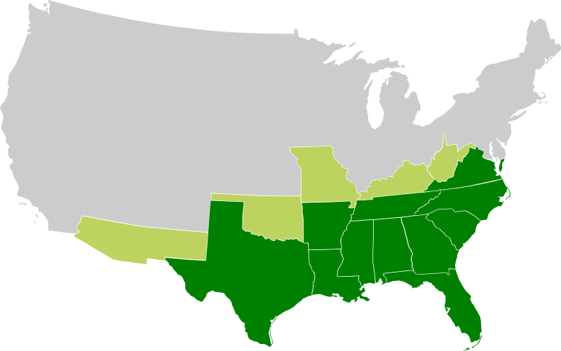
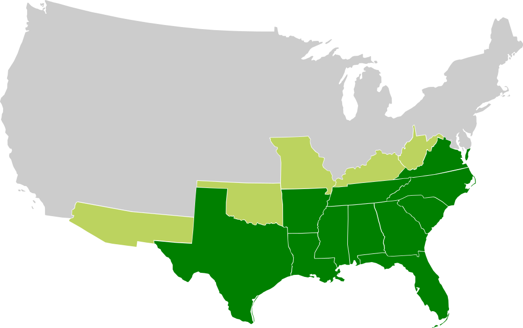
A map of the Confederate States of America, Maryland and claimed states and territories.
States that seceeded under CSA control
States and territories claimed by CSA without formal secession and/or control |
| စၟတ်တ္ၚဲ | |
| တမ်ရိုဟ် | ကမၠောန် ဇကုအပိုင် |
| ကဝိ |
|
| အခြား ဗားရှင်းများ | File:Csa5-3.gif |
မသ္ဂုတ်သွာတ်လာင်ဇြေန်
ဝှာင်ဏအ်ဂှ် စၟတ်သမ္တီလဝ် နကဵုလာင်ဇြေန် Creative Commons Attribution-Share Alike 3.0 Unported ရ၊၊
- မၞးဂှ် ဗွဲမဗၠးၜး -
- သွက်ဂွံ ပါ်ပရအ် – သွက်ဂွံ စၠောအ်ပပ်ပဳ၊ တြးပတိတ်၊ ဗလး ကမၠောန်
- သွက်ဂွံ ပကောံနှဴ – သွက်ဂွံ ပလေဝ်ပညဳ ကမၠောန်
- နကဵု တင်မသ္ဒးဒ္ဂေတ်ဗက် ဗွဲသၟဝ်ဏအ်ဂှ်
- တင်မစှ်ေစိုတ် – မၞး သ္ဒးဒ္ဂေတ်ဗက် သၞောတ်ဝ် မဖျေဟ်လဝ် စပ်ကဵု အစာချူလိက် ဟွံသေင်မ္ဂး တၠမူတအ်ရောင်၊၊ (ဆဂး နကဵုနဲလဵု အကာဲအရာ ဗီုလဵုလေဝ် ဟွံကဵုကသပ် ဟွံထံက်ဂလာန် ကုမၞး ပ္ဍဲအရာမစကာ ဒြပ်ညးတၞဟ်တအ်ရောင်)။
- ပါ်ပရအ် အရာမတုပ်သၟဟ် – ယဝ်ရ မၞး ပလေဝ်၊ ပြံင်လှာဲ ဟွံသေင်မ္ဂး ထပ်ခၞံဗဒှ်တၟိမ္ဂး အရာကမၠောန်တအ် သီုဖအိုတ်ဂှ် သ္ဒးပရးပတိတ် နကဵုသၟဝ် မတုပ် ဟွံသေင်မ္ဂး မသၟဟ် ကုလာင်ဇြေန် ကမၠောန်တြေံဂှ် ဟေင်ရ၊၊
ဝှာင် လၟေင်အပြံင်အလှာဲ
ဍဵု လတူ စၟတ်တ္ၚဲ/အခိင် မွဲမွဲ သွက်ဂွံ ထ္ၜးကဵု ဝှာင် မကတဵုဒှ်လဝ် ပ္ဍဲအခိင်ဂှ်၊၊
| စၟတ်တ္ၚဲ/အခိင် | ဗီုပြင်နမူနာ | ပမာဏ | ညးလွပ် | တင်ပသောင်ကလး | |
|---|---|---|---|---|---|
| လၟုဟ် | ၂၂:၅၃၊ ၂၇ နဝ်ဝေမ်ဗါ ၂၀၀၉ | | ၉၁၃ × ၅၇၂ (၅၇ KB) | Lexicon | Reverted to version as of 08:57, 21 March 2008 as new version is different image used for different purposes, and not an SVG file |
| ၀၇:၂၆၊ ၂၆ နဝ်ဝေမ်ဗါ ၂၀၀၉ |  | ၆၄၀ × ၄၁၉ (၃၄ KB) | Major General Sterling Price | this is the Confederate States today if they won the Civil War | |
| ၁၅:၂၇၊ ၂၁ မာတ် ၂၀၀၈ |  | ၉၁၃ × ၅၇၂ (၅၇ KB) | Nkocharh | I forgot Kentucky! | |
| ၁၅:၁၉၊ ၂၁ မာတ် ၂၀၀၈ |  | ၉၁၃ × ၅၇၂ (၅၅ KB) | Nkocharh | {{Information |Description=A map of the Confederate Sates of America |Source=self-made |Date=21 March 2008 |Author= Nkocharh |Permission= |other_versions= }} |
ဝှာင် ဗီုဂွံစကာ
မုက်လိက် မရပ်စပ် ဝှာင်ဏအ် ဟွံမဲ၊၊
ဝှာင် သွက်ဂွံသုင်စောဲ ဂလုပ်ဗဴ
ဗွဲသၟဝ်ဏအ်ဂှ် ဒှ်အရာ ဝဳကဳတၞဟ် မစကာလဝ် ဝှာင်ဏအ်၊၊
- ဗီုစကာ ပ္ဍဲ af.wikipedia.org
- ဗီုစကာ ပ္ဍဲ arz.wikipedia.org
- ဗီုစကာ ပ္ဍဲ bn.wikipedia.org
- ဗီုစကာ ပ္ဍဲ br.wikipedia.org
- ဗီုစကာ ပ္ဍဲ da.wikipedia.org
- ဗီုစကာ ပ္ဍဲ de.wikipedia.org
- ဗီုစကာ ပ္ဍဲ el.wikipedia.org
- ဗီုစကာ ပ္ဍဲ en.wikipedia.org
- Alabama
- Arkansas
- Confederate States of America
- Louisiana
- North Carolina
- South Carolina
- Texas
- Tennessee
- Virginia
- West Virginia
- Georgia (U.S. state)
- Confederate Arizona
- West Virginia in the American Civil War
- User:Nkocharh
- Missouri in the American Civil War
- Florida in the American Civil War
- Kentucky in the American Civil War
- Alabama in the American Civil War
- Mississippi in the American Civil War
- South Carolina in the American Civil War
- Tennessee in the American Civil War
- Texas in the American Civil War
- Georgia in the American Civil War
- North Carolina in the American Civil War
- Virginia in the American Civil War
- Template:Confederate States political divisions
- Arkansas in the American Civil War
- Louisiana in the American Civil War
- Confederate government of Kentucky
- Wikipedia:Graphics Lab/Images to improve/Archive/Mar 2008
- Mississippi
- Secession in the United States
- Florida
- Conclusion of the American Civil War
- 1861 in the United States
- Talk:Muscogee Nation
- Confederate government of Missouri
ဗဵု more global usage ဝှာင်ဏအ်၊၊