
ဝှာင်:Devon UK location map.svg

Size of this PNG preview of this SVG file: ၆၅၃ × ၆၀၀ pixels. အရာမသ္ဂုတ်သွာတ်လဝ်ဂမၠိုၚ်: ၂၆၁ × ၂၄၀ pixels | ၅၂၃ × ၄၈၀ pixels | ၈၃၆ × ၇၆၈ pixels | ၁၁၁၅ × ၁၀၂၄ pixels | ၂၂၂၉ × ၂၀၄၈ pixels | ၁၂၉၂ × ၁၁၈၇ pixels တၞဟ်။
ဝှာင် တမ်မူလ (SVG ဝှာင်, မိက်ကဵုကသပ် ၁၂၉၂ × ၁၁၈၇ pixels, ဇမၞော် ဝှာင်: ၂.၄၃ MB)
| ကဵုယၟု |
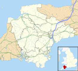
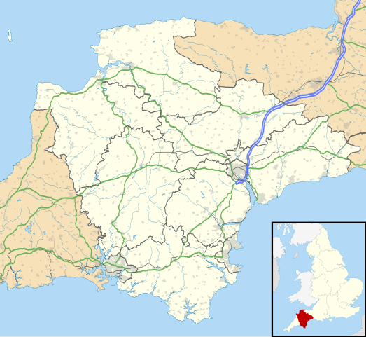
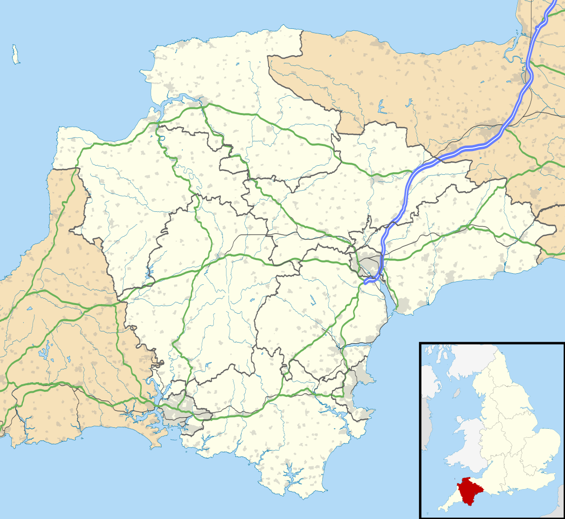
Map of Devon, UK with the following information shown:
Equirectangular map projection on WGS 84 datum, with N/S stretched 150% Geographic limits:
|
| စၟတ်တ္ၚဲ | |
| တမ်ရိုဟ် |
|
| ကဝိ | Nilfanion, created using Ordnance Survey data |
| တင်မကဵုအခေါင် (ကလေင်သုင်စောဲ ဝှာင်ဏအ်) |
ဝှာင်ဏအ်ဂှ် စၟတ်သမ္တီလဝ် နကဵုလာင်ဇြေန် Creative Commons Attribution-Share Alike 3.0 Unported ရ၊၊ ဒဒှ်မစၟတ်သမ္တီကေတ်: Contains Ordnance Survey data © Crown copyright and database right
|
| အခြား ဗားရှင်းများ | File:Devon UK district map (blank).svg - Blank map with administrative borders only. |
.svg)
ဝှာင် လၟေင်အပြံင်အလှာဲ
ဍဵု လတူ စၟတ်တ္ၚဲ/အခိင် မွဲမွဲ သွက်ဂွံ ထ္ၜးကဵု ဝှာင် မကတဵုဒှ်လဝ် ပ္ဍဲအခိင်ဂှ်၊၊
| စၟတ်တ္ၚဲ/အခိင် | ဗီုပြင်နမူနာ | ပမာဏ | ညးလွပ် | တင်ပသောင်ကလး | |
|---|---|---|---|---|---|
| လၟုဟ် | ၀၁:၁၈၊ ၂၇ သေပ်တေမ်ဗါ ၂၀၁၀ | | ၁၂၉၂ × ၁၁၈၇ (၂.၄၃ MB) | Nilfanion | tweak motorways... |
| ၀၆:၂၆၊ ၇ သေပ်တေမ်ဗါ ၂၀၁၀ |  | ၁၂၉၂ × ၁၁၈၇ (၂.၆၄ MB) | Nilfanion | Tweaking urban areas, road colours and boundary lines | |
| ၀၃:၂၄၊ ၅ သေပ်တေမ်ဗါ ၂၀၁၀ |  | ၁၂၉၂ × ၁၁၈၇ (၂.၄ MB) | Nilfanion | {{Information |Description=Map of Devon, UK with the following information shown: *Administrative borders *Coastline, lakes and rivers *Motorways and primary routes *Urban areas Equirectangular map projection on WGS 84 datum, with N/S stretch |
ဝှာင် ဗီုဂွံစကာ
မုက်လိက် မရပ်စပ် ဝှာင်ဏအ် ဟွံမဲ၊၊
ဝှာင် သွက်ဂွံသုင်စောဲ ဂလုပ်ဗဴ
ဗွဲသၟဝ်ဏအ်ဂှ် ဒှ်အရာ ဝဳကဳတၞဟ် မစကာလဝ် ဝှာင်ဏအ်၊၊
- ဗီုစကာ ပ္ဍဲ ar.wikipedia.org
- ဗီုစကာ ပ္ဍဲ arz.wikipedia.org
- ဗီုစကာ ပ္ဍဲ azb.wikipedia.org
- هونیتون
- هولسوورتی، دوون
- هارتلند، دوون
- هاترلی، دوون
- نیوتون آبوت
- نورث تاوتون
- نورتهام، دوون
- مورتونهامپستید
- کینقزبریج
- کولیتون، دوون
- کردیتون
- کالومپتون
- قریت تورینقتون
- سیدموث
- سیتون، دوون
- ساوت مولتون
- سالکومب
- دونپورت، پلیموث
- داولیش
- دارتموث، دوون
- چالملی
- چاقفورد
- چادلی
- تیورتون، دوون
- تینموث
- تورکی
- توتنس
- تاویستوک، دوون
- پینتون
- پلمپتون
- بیدفورد
- بووی تریسی
- بودلی سالترتون
- بریکسهام
- برانسکومب
- برادنینچ
- باکفستلی
- بارنستاپل
- آیویبریج
- ایلفراکم
- اوکهامپتون
- اوتری سنت ماری
- اکسمینستر
- اکسموث
- اشبورتون، دوون
- ဗီုစကာ ပ္ဍဲ bg.wikipedia.org
ဗဵု more global usage ဝှာင်ဏအ်၊၊