
ဝှာင်:England and Wales population cartogram districts.svg

Size of this PNG preview of this SVG file: ၅၂၅ × ၅၉၉ pixels. အရာမသ္ဂုတ်သွာတ်လဝ်ဂမၠိုၚ်: ၂၁၀ × ၂၄၀ pixels | ၄၂၁ × ၄၈၀ pixels | ၆၇၃ × ၇၆၈ pixels | ၈၉၇ × ၁၀၂၄ pixels | ၁၇၉၅ × ၂၀၄၈ pixels | ၁၀၂၂ × ၁၁၆၆ pixels တၞဟ်။
ဝှာင် တမ်မူလ (SVG ဝှာင်, မိက်ကဵုကသပ် ၁၀၂၂ × ၁၁၆၆ pixels, ဇမၞော် ဝှာင်: ၈၀၅ KB)
သကေမ်
| ကဵုယၟု |
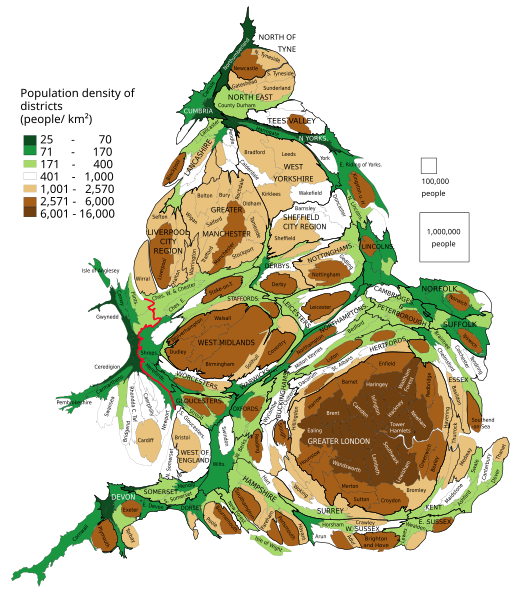
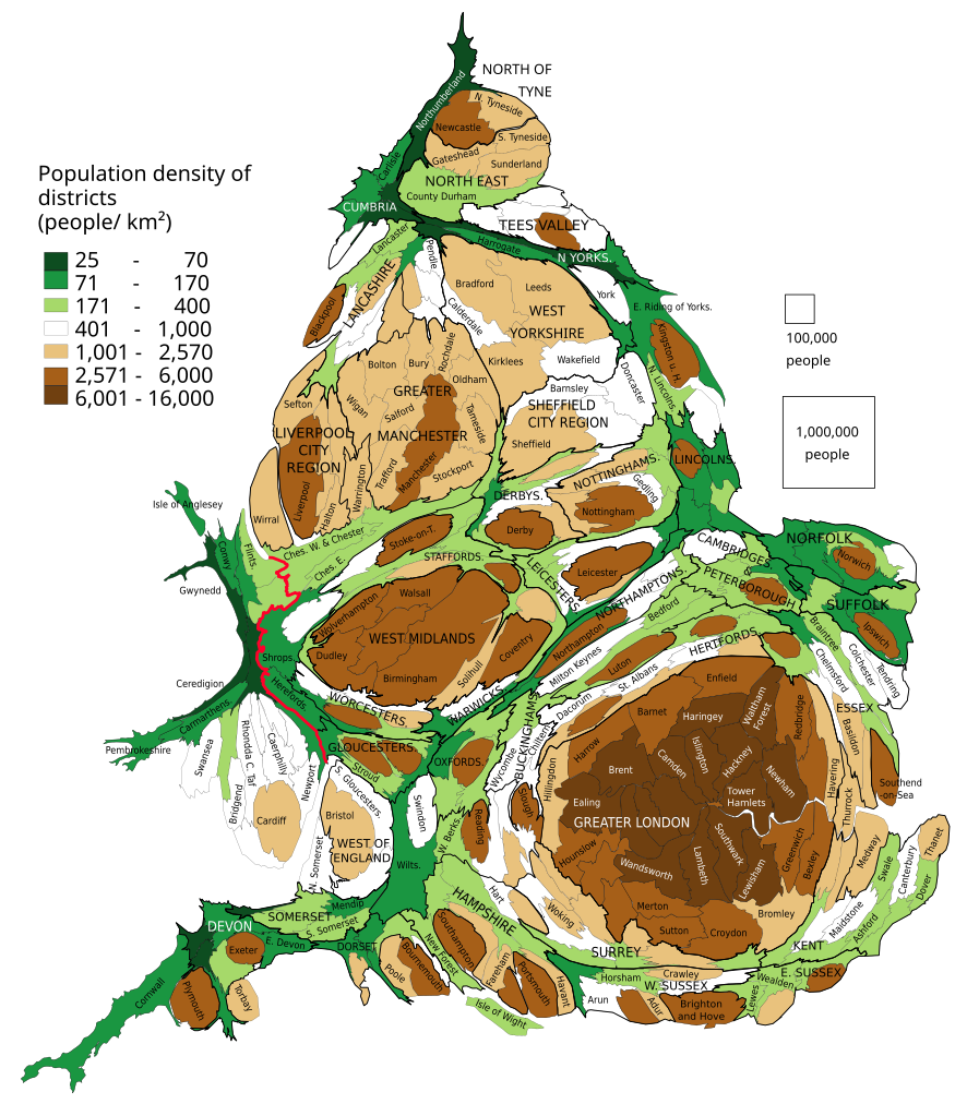
English: Population of districts. Their size shows their population, with some approximation, according to 2011 Census data. Each group of squares in the map key is 20 % of total number of districts.
Polski: Kartogram ludności Anglii i Walii. Liczba mieszkańców dystryktów. Wielkość dystryktów pokazuje liczbę jego mieszkańców, z pewnym przybliżeniem według danych z cenzusu z 2011. Każda grupa kwadratów w legendzie to 20 % liczby wszystkich dystryktów. |
| စၟတ်တ္ၚဲ | |
| တမ်ရိုဟ် | Own work based on: population density from Population Estimates for UK, England and Wales, Scotland and Northern Ireland - Office for National Statistics, 2015 |
| ကဝိ | PawełS |
| SVG genesis |
Software:
- ScapeToad (First grid 1 600; Diffusion grid size 1024; 8 iterations)
- QGIS: Cartogram Creator plugin 10 iterations
မသ္ဂုတ်သွာတ်လာင်ဇြေန်
ကျွန်ုပ်၊ ဤလုပ်ဆောင်ချက်၏ မူပိုင်ခွင့်ပိုင်ရှင်အနေဖြင့် ဤနေရာမှ အောက်ပါလိုင်စင်အောက်တွင် ထုတ်လွှင့်ပါသည်:
ဝှာင်ဏအ်ဂှ် စၟတ်သမ္တီလဝ် နကဵုလာင်ဇြေန် Creative Commons Attribution-Share Alike 3.0 Unported ရ၊၊
- မၞးဂှ် ဗွဲမဗၠးၜး -
- သွက်ဂွံ ပါ်ပရအ် – သွက်ဂွံ စၠောအ်ပပ်ပဳ၊ တြးပတိတ်၊ ဗလး ကမၠောန်
- သွက်ဂွံ ပကောံနှဴ – သွက်ဂွံ ပလေဝ်ပညဳ ကမၠောန်
- နကဵု တင်မသ္ဒးဒ္ဂေတ်ဗက် ဗွဲသၟဝ်ဏအ်ဂှ်
- တင်မစှ်ေစိုတ် – မၞး သ္ဒးဒ္ဂေတ်ဗက် သၞောတ်ဝ် မဖျေဟ်လဝ် စပ်ကဵု အစာချူလိက် ဟွံသေင်မ္ဂး တၠမူတအ်ရောင်၊၊ (ဆဂး နကဵုနဲလဵု အကာဲအရာ ဗီုလဵုလေဝ် ဟွံကဵုကသပ် ဟွံထံက်ဂလာန် ကုမၞး ပ္ဍဲအရာမစကာ ဒြပ်ညးတၞဟ်တအ်ရောင်)။
- ပါ်ပရအ် အရာမတုပ်သၟဟ် – ယဝ်ရ မၞး ပလေဝ်၊ ပြံင်လှာဲ ဟွံသေင်မ္ဂး ထပ်ခၞံဗဒှ်တၟိမ္ဂး အရာကမၠောန်တအ် သီုဖအိုတ်ဂှ် သ္ဒးပရးပတိတ် နကဵုသၟဝ် မတုပ် ဟွံသေင်မ္ဂး မသၟဟ် ကုလာင်ဇြေန် ကမၠောန်တြေံဂှ် ဟေင်ရ၊၊
ဝှာင် လၟေင်အပြံင်အလှာဲ
ဍဵု လတူ စၟတ်တ္ၚဲ/အခိင် မွဲမွဲ သွက်ဂွံ ထ္ၜးကဵု ဝှာင် မကတဵုဒှ်လဝ် ပ္ဍဲအခိင်ဂှ်၊၊
| စၟတ်တ္ၚဲ/အခိင် | ဗီုပြင်နမူနာ | ပမာဏ | ညးလွပ် | တင်ပသောင်ကလး | |
|---|---|---|---|---|---|
| လၟုဟ် | ၂၃:၄၄၊ ၁၃ ဖေဖဝ်ဝါရဳ ၂၀၁၉ | | ၁၀၂၂ × ၁၁၆၆ (၈၀၅ KB) | PawełS | combined authorities |
| ၀၃:၃၈၊ ၂၃ မာတ် ၂၀၁၇ |  | ၁၀၂၂ × ၁၁၆၆ (၇၈၃ KB) | PawełS | Haringey and Devon font colour | |
| ၂၁:၀၄၊ ၁၉ မာတ် ၂၀၁၇ |  | ၁၀၂၂ × ၁၁၆၆ (၇၈၃ KB) | PawełS | + population density | |
| ၀၀:၃၁၊ ၁၇ ဇာန်နဝါရဳ ၂၀၁၄ |  | ၁၀၂၄ × ၁၁၈၈ (၁ MB) | PawełS | Fonts size | |
| ၀၀:၁၉၊ ၁၇ ဇာန်နဝါရဳ ၂၀၁၄ |  | ၁၀၂၄ × ၁၁၈၈ (၁.၁ MB) | PawełS | Bold England-Wales border | |
| ၀၂:၃၁၊ ၂၅ မာတ် ၂၀၁၃ |  | ၁၀၂၄ × ၁၁၈၈ (၁.၁ MB) | PawełS | Trying to fix fonts appearance in thumb | |
| ၀၀:၄၆၊ ၁၅ မာတ် ၂၀၁၃ |  | ၁၀၂၄ × ၁၁၈၈ (၁.၁ MB) | PawełS | User created page with UploadWizard |
ဝှာင် ဗီုဂွံစကာ
မုက်လိက် မရပ်စပ် ဝှာင်ဏအ် ဟွံမဲ၊၊
ဝှာင် သွက်ဂွံသုင်စောဲ ဂလုပ်ဗဴ
ဗွဲသၟဝ်ဏအ်ဂှ် ဒှ်အရာ ဝဳကဳတၞဟ် မစကာလဝ် ဝှာင်ဏအ်၊၊
- ဗီုစကာ ပ္ဍဲ en.wikipedia.org
- ဗီုစကာ ပ္ဍဲ is.wikipedia.org
- ဗီုစကာ ပ္ဍဲ ku.wikipedia.org
- ဗီုစကာ ပ္ဍဲ pl.wikipedia.org
- ဗီုစကာ ပ္ဍဲ vi.wikipedia.org