
ဝှာင်:Essex UK locator map 2010.svg

Size of this PNG preview of this SVG file: ၄၉၄ × ၆၀၀ pixels. အရာမသ္ဂုတ်သွာတ်လဝ်ဂမၠိုၚ်: ၁၉၈ × ၂၄၀ pixels | ၃၉၅ × ၄၈၀ pixels | ၆၃၃ × ၇၆၈ pixels | ၈၄၃ × ၁၀၂၄ pixels | ၁၆၈၇ × ၂၀၄၈ pixels | ၁၁၀၈ × ၁၃၄၅ pixels တၞဟ်။
ဝှာင် တမ်မူလ (SVG ဝှာင်, မိက်ကဵုကသပ် ၁၁၀၈ × ၁၃၄၅ pixels, ဇမၞော် ဝှာင်: ၃၀၂ KB)
သကေမ်
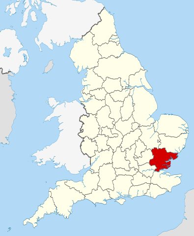
| ကဵုယၟု | Location of the ceremonial county of Essex within England. |
| စၟတ်တ္ၚဲ | |
| တမ်ရိုဟ် |
National Geospatial-Intelligence Agency
|
| ကဝိ | Nilfanion |
| SVG genesis |
မသ္ဂုတ်သွာတ်လာင်ဇြေန်
ကျွန်ုပ်၊ ဤလုပ်ဆောင်ချက်၏ မူပိုင်ခွင့်ပိုင်ရှင်အနေဖြင့် ဤနေရာမှ အောက်ပါလိုင်စင်များအောက်တွင် ထုတ်လွှင့်ပါသည်:
ဝှာင်ဏအ်ဂှ် စၟတ်သမ္တီလဝ် နကဵုလာင်ဇြေန် Creative Commons Attribution-Share Alike 3.0 Unported ရ၊၊
- မၞးဂှ် ဗွဲမဗၠးၜး -
- သွက်ဂွံ ပါ်ပရအ် – သွက်ဂွံ စၠောအ်ပပ်ပဳ၊ တြးပတိတ်၊ ဗလး ကမၠောန်
- သွက်ဂွံ ပကောံနှဴ – သွက်ဂွံ ပလေဝ်ပညဳ ကမၠောန်
- နကဵု တင်မသ္ဒးဒ္ဂေတ်ဗက် ဗွဲသၟဝ်ဏအ်ဂှ်
- တင်မစှ်ေစိုတ် – မၞး သ္ဒးဒ္ဂေတ်ဗက် သၞောတ်ဝ် မဖျေဟ်လဝ် စပ်ကဵု အစာချူလိက် ဟွံသေင်မ္ဂး တၠမူတအ်ရောင်၊၊ (ဆဂး နကဵုနဲလဵု အကာဲအရာ ဗီုလဵုလေဝ် ဟွံကဵုကသပ် ဟွံထံက်ဂလာန် ကုမၞး ပ္ဍဲအရာမစကာ ဒြပ်ညးတၞဟ်တအ်ရောင်)။
- ပါ်ပရအ် အရာမတုပ်သၟဟ် – ယဝ်ရ မၞး ပလေဝ်၊ ပြံင်လှာဲ ဟွံသေင်မ္ဂး ထပ်ခၞံဗဒှ်တၟိမ္ဂး အရာကမၠောန်တအ် သီုဖအိုတ်ဂှ် သ္ဒးပရးပတိတ် နကဵုသၟဝ် မတုပ် ဟွံသေင်မ္ဂး မသၟဟ် ကုလာင်ဇြေန် ကမၠောန်တြေံဂှ် ဟေင်ရ၊၊

|
လိက်တအ်ဂှ် သၠးကဵုလဝ် အခေါင် သွက်ဂွံ စၠောအ်ကပ်ပဳ၊ ပရး ကီု သီုကဵု ပလေဝ်ပခိုဟ်ပတိုန် အတိုင်သၞောတ်ဝ် GNU Free Documentation License, တုဲ မူ ၁.၂ ဟွံသေင်မ္ဂး မူတြေံနူဂှ် မတြးပတိတ် နကဵု သၞောတ်ဝ်လာင်ဇြေန် Free Software Foundation; with no Invariant Sections, no Front-Cover Texts, and no Back-Cover Texts. A copy of the license is included in the section entitled GNU Free Documentation License. |
လာင်ဇြေန် မၞး မၞုံပၟိက်ဂှ် မၞးရုဲစှ်ကေတ် မာန်ရ၊၊

|
This is one of the images forming part of the Valued image set: Locator maps of the Ceremonial counties of England on Wikimedia Commons. The image set has been assessed under the valued image set criteria and is considered the most valued set on Commons within the scope:
Locator maps of the Ceremonial counties of England
You can see its nomination at Commons:Valued image candidates/Locator maps of English ceremonial counties. |
ဝှာင် လၟေင်အပြံင်အလှာဲ
ဍဵု လတူ စၟတ်တ္ၚဲ/အခိင် မွဲမွဲ သွက်ဂွံ ထ္ၜးကဵု ဝှာင် မကတဵုဒှ်လဝ် ပ္ဍဲအခိင်ဂှ်၊၊
| စၟတ်တ္ၚဲ/အခိင် | ဗီုပြင်နမူနာ | ပမာဏ | ညးလွပ် | တင်ပသောင်ကလး | |
|---|---|---|---|---|---|
| လၟုဟ် | ၀၅:၀၆၊ ၂၄ နဝ်ဝေမ်ဗါ ၂၀၁၀ | | ၁၁၀၈ × ၁၃၄၅ (၃၀၂ KB) | Nilfanion | == Summary == {{Information |Description=Location of the ceremonial county of Essex within England. |Source=Ordnance Survey [https://www.ordnancesurvey.co.uk/opendatadownload/products.html OpenData]: *County boundaries an |
ဝှာင် ဗီုဂွံစကာ
မုက်လိက် မရပ်စပ် ဝှာင်ဏအ် ဟွံမဲ၊၊
ဝှာင် သွက်ဂွံသုင်စောဲ ဂလုပ်ဗဴ
ဗွဲသၟဝ်ဏအ်ဂှ် ဒှ်အရာ ဝဳကဳတၞဟ် မစကာလဝ် ဝှာင်ဏအ်၊၊
- ဗီုစကာ ပ္ဍဲ af.wikipedia.org
- ဗီုစကာ ပ္ဍဲ an.wikipedia.org
- ဗီုစကာ ပ္ဍဲ arz.wikipedia.org
- ဗီုစကာ ပ္ဍဲ ast.wikipedia.org
- ဗီုစကာ ပ္ဍဲ be-tarask.wikipedia.org
- ဗီုစကာ ပ္ဍဲ be.wikipedia.org
- ဗီုစကာ ပ္ဍဲ bg.wikipedia.org
- ဗီုစကာ ပ္ဍဲ bn.wikipedia.org
- ဗီုစကာ ပ္ဍဲ br.wikipedia.org
- ဗီုစကာ ပ္ဍဲ ca.wikipedia.org
- ဗီုစကာ ပ္ဍဲ ceb.wikipedia.org
- ဗီုစကာ ပ္ဍဲ cs.wikipedia.org
- ဗီုစကာ ပ္ဍဲ dag.wikipedia.org
- ဗီုစကာ ပ္ဍဲ el.wikipedia.org
- ဗီုစကာ ပ္ဍဲ en.wikipedia.org
- Debden, Uttlesford
- Stour Estuary RSPB reserve
- Point Clear
- Ugley
- Takeley
- Saffron Walden Rural District
- Wivenhoe Park
- Steeple, Essex
- Chignall Smealy
- Prittlewell Square
- River Roding
- New England Island
- Potton Island
- Marks Tey
- Lawford
- Fingringhoe
- Hadstock
- Duddenhoe End
- Essex girl
- Tolleshunt Knights
- Nounsley
- Benfleet Urban District
- Canvey Island Urban District
- Rochford Rural District
- Abberton, Essex
- Template:Essex-geo-stub
- River Brain
- Bradfield, Essex
- Childerditch
- Great Warley
- Stondon Massey
- Ingrave
- Little Warley
- Abbess, Beauchamp and Berners Roding
- Alphamstone
ဗဵု more global usage ဝှာင်ဏအ်၊၊