
ဝှာင်:Europe ISO 3166-1.svg

Size of this PNG preview of this SVG file: ၇၀၀ × ၅၁၂ pixels. အရာမသ္ဂုတ်သွာတ်လဝ်ဂမၠိုၚ်: ၃၂၀ × ၂၃၄ pixels | ၆၄၀ × ၄၆၈ pixels | ၁၀၂၄ × ၇၄၉ pixels | ၁၂၈၀ × ၉၃၆ pixels | ၂၅၆၀ × ၁၈၇၂ pixels တၞဟ်။
ဝှာင် တမ်မူလ (SVG ဝှာင်, မိက်ကဵုကသပ် ၇၀၀ × ၅၁၂ pixels, ဇမၞော် ဝှာင်: ၃၈၄ KB)
သကေမ်
| ကဵုယၟု |
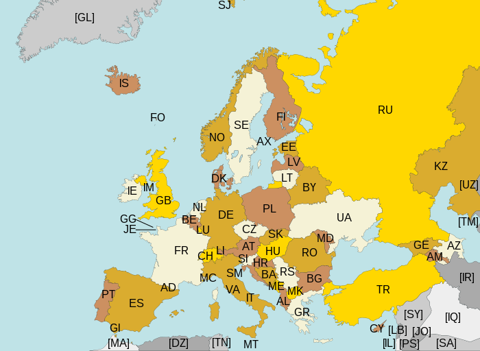
Map of Europe, with ISO 3166-1 pt · en country and territory codes. SVG format. Map legend in Portuguese and English, with name of sovereign state given in parenthesis, where applicable:
Non-European countries and territories featured in map:
|
| စၟတ်တ္ၚဲ | |
| တမ်ရိုဟ် | ကမၠောန် ဇကုအပိုင် |
| ကဝိ | Júlio Reis |
| အခြား ဗားရှင်းများ | Without country codes: Europe countries.svg · Only continent boundaries: Europe continents.svg · Country names in Italian: Europa-it-politica-names-big.svg · Including Kosovo: Europe ISO 3166-1 (with Kosovo).svg |
| SVG genesis |
.svg)
မသ္ဂုတ်သွာတ်လာင်ဇြေန်
ဝှာင်ဏအ်ဂှ် စၟတ်သမ္တီလဝ် နကဵုလာင်ဇြေန် Creative Commons Attribution-Share Alike 3.0 Unported ရ၊၊
- မၞးဂှ် ဗွဲမဗၠးၜး -
- သွက်ဂွံ ပါ်ပရအ် – သွက်ဂွံ စၠောအ်ပပ်ပဳ၊ တြးပတိတ်၊ ဗလး ကမၠောန်
- သွက်ဂွံ ပကောံနှဴ – သွက်ဂွံ ပလေဝ်ပညဳ ကမၠောန်
- နကဵု တင်မသ္ဒးဒ္ဂေတ်ဗက် ဗွဲသၟဝ်ဏအ်ဂှ်
- တင်မစှ်ေစိုတ် – မၞး သ္ဒးဒ္ဂေတ်ဗက် သၞောတ်ဝ် မဖျေဟ်လဝ် စပ်ကဵု အစာချူလိက် ဟွံသေင်မ္ဂး တၠမူတအ်ရောင်၊၊ (ဆဂး နကဵုနဲလဵု အကာဲအရာ ဗီုလဵုလေဝ် ဟွံကဵုကသပ် ဟွံထံက်ဂလာန် ကုမၞး ပ္ဍဲအရာမစကာ ဒြပ်ညးတၞဟ်တအ်ရောင်)။
- ပါ်ပရအ် အရာမတုပ်သၟဟ် – ယဝ်ရ မၞး ပလေဝ်၊ ပြံင်လှာဲ ဟွံသေင်မ္ဂး ထပ်ခၞံဗဒှ်တၟိမ္ဂး အရာကမၠောန်တအ် သီုဖအိုတ်ဂှ် သ္ဒးပရးပတိတ် နကဵုသၟဝ် မတုပ် ဟွံသေင်မ္ဂး မသၟဟ် ကုလာင်ဇြေန် ကမၠောန်တြေံဂှ် ဟေင်ရ၊၊
ဝှာင် လၟေင်အပြံင်အလှာဲ
ဍဵု လတူ စၟတ်တ္ၚဲ/အခိင် မွဲမွဲ သွက်ဂွံ ထ္ၜးကဵု ဝှာင် မကတဵုဒှ်လဝ် ပ္ဍဲအခိင်ဂှ်၊၊
| စၟတ်တ္ၚဲ/အခိင် | ဗီုပြင်နမူနာ | ပမာဏ | ညးလွပ် | တင်ပသောင်ကလး | |
|---|---|---|---|---|---|
| လၟုဟ် | ၀၅:၁၃၊ ၁၁ အဝ်ဂေတ် ၂၀၁၅ | | ၇၀၀ × ၅၁၂ (၃၈၄ KB) | SiBr4 | Increasing contrast by slightly changing the map colors; splitting Serbia and Montenegro; cropping some more; plain SVG |
| ၀၁:၁၆၊ ၁၁ ဨပြဳ ၂၀၁၂ |  | ၈၀၀ × ၅၁၂ (၄၂၁ KB) | Ras67 | "cropped" | |
| ၁၁:၂၂၊ ၁၃ မာတ် ၂၀၁၁ |  | ၈၀၀ × ၅၂၀ (၅၉၇ KB) | Chipmunkdavis | Fixing Turkey, adding Gibraltar | |
| ၀၅:၄၁၊ ၂၃ အဝ်ဂေတ် ၂၀၀၉ |  | ၈၀၀ × ၅၂၀ (၅၉၉ KB) | Tintazul | Croatia, Palestine | |
| ၀၅:၄၅၊ ၅ နဝ်ဝေမ်ဗါ ၂၀၀၇ |  | ၈၀၀ × ၅၂၀ (၆၀၁ KB) | Lupo | Re-upload; trying to fix wrong MIME type | |
| ၁၉:၃၆၊ ၁၄ အဝ်ဂေတ် ၂၀၀၇ | ဗီုပြင်နမူနာ ဟွံမဲ | (၆၀၁ KB) | Tintazul | replaced CS with RS+ME; replaced UK with GB; added AX, SJ, FO, IM, GG, JE | |
| ၀၈:၀၂၊ ၁၁ ဇာန်နဝါရဳ ၂၀၀၇ |  | ၈၀၀ × ၅၂၀ (၅၉၄ KB) | Angus | PT → HR | |
| ၀၄:၂၁၊ ၈ ဂျောန် ၂၀၀၆ |  | ၈၀၀ × ၅၂၀ (၅၉၄ KB) | Tintazul | {{Tintazul| |Description=Map of Europe, with ISO 3166-1 <sup>pt · en</sup> country and territory codes. SVG format. Map legend in Portuguese and English, with name of sovereign state given in parenthesis, where appl |
ဝှာင် ဗီုဂွံစကာ
မုက်လိက် မရပ်စပ် ဝှာင်ဏအ် ဟွံမဲ၊၊
ဝှာင် သွက်ဂွံသုင်စောဲ ဂလုပ်ဗဴ
ဗွဲသၟဝ်ဏအ်ဂှ် ဒှ်အရာ ဝဳကဳတၞဟ် မစကာလဝ် ဝှာင်ဏအ်၊၊
- ဗီုစကာ ပ္ဍဲ ar.wikipedia.org
- ဗီုစကာ ပ္ဍဲ arz.wikipedia.org
- ဗီုစကာ ပ္ဍဲ bg.wikipedia.org
- ဗီုစကာ ပ္ဍဲ bn.wikipedia.org
- ဗီုစကာ ပ္ဍဲ cs.wikipedia.org
- ဗီုစကာ ပ္ဍဲ en.wikipedia.org
- ဗီုစကာ ပ္ဍဲ eo.wikipedia.org
- ဗီုစကာ ပ္ဍဲ es.wikipedia.org
- ဗီုစကာ ပ္ဍဲ fi.wikipedia.org
- ဗီုစကာ ပ္ဍဲ fo.wikipedia.org
- ဗီုစကာ ပ္ဍဲ fr.wikipedia.org
- ဗီုစကာ ပ္ဍဲ gl.wikipedia.org
- ဗီုစကာ ပ္ဍဲ he.wikipedia.org
- ဗီုစကာ ပ္ဍဲ id.wikipedia.org
- ဗီုစကာ ပ္ဍဲ ilo.wikipedia.org
- ဗီုစကာ ပ္ဍဲ ja.wikipedia.org
- ဗီုစကာ ပ္ဍဲ ka.wikipedia.org
- ဗီုစကာ ပ္ဍဲ lt.wikipedia.org
- ဗီုစကာ ပ္ဍဲ mk.wikipedia.org
- ဗီုစကာ ပ္ဍဲ nl.wikipedia.org
- ဗီုစကာ ပ္ဍဲ no.wikipedia.org
- ဗီုစကာ ပ္ဍဲ pt.wikipedia.org
- ဗီုစကာ ပ္ဍဲ ru.wikipedia.org
- ဗီုစကာ ပ္ဍဲ rw.wikipedia.org
- ဗီုစကာ ပ္ဍဲ si.wikipedia.org
- ဗီုစကာ ပ္ဍဲ sr.wikipedia.org
- ဗီုစကာ ပ္ဍဲ su.wikipedia.org
- ဗီုစကာ ပ္ဍဲ ta.wikipedia.org
- ဗီုစကာ ပ္ဍဲ www.wikidata.org
- ဗီုစကာ ပ္ဍဲ zh.wikipedia.org