
ဝှာင်:Katrina-new-orleans-flooding3-2005.jpg
ဇမၞော် နမူနာ ဏအ် - ၈၀၀ × ၆၀၀ pixels အရာမသ္ဂုတ်သွာတ်လဝ်ဂမၠိုၚ်: ၃၂၀ × ၂၄၀ pixels | ၆၄၀ × ၄၈၀ pixels | ၁၀၂၄ × ၇၆၈ pixels | ၁၂၈၀ × ၉၆၀ pixels | ၁၆၀၀ × ၁၂၀၀ pixels တၞဟ်။
ဝှာင် တမ်မူလ (၁၆၀၀ × ၁၂၀၀ pixels, file size: ၁.၀၅ MB, MIME type: image/jpeg)
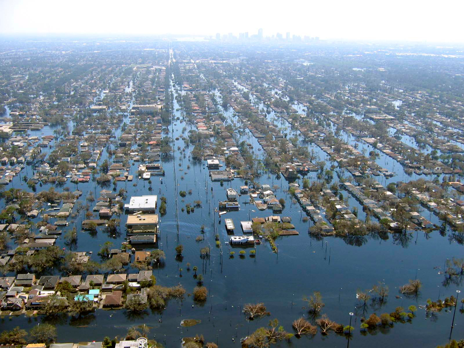
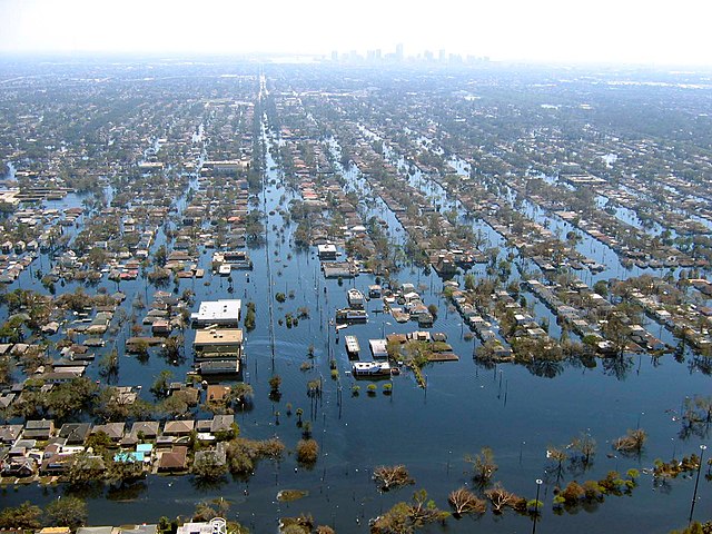
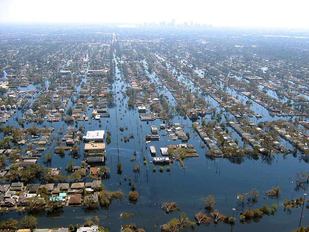
| ကဵုယၟု | View of flooded New Orleans, Louisiana in the aftermath of Hurricane Katrina | |||
| စၟတ်တ္ၚဲ | ||||
| တမ်ရိုဟ် | http://www.katrina.noaa.gov/helicopter/helicopter-2.html | |||
| ကဝိ | Commander Mark Moran, of the NOAA Aviation Weather Center, and Lt. Phil Eastman and Lt. Dave Demers, of the NOAA Aircraft Operations Center, all commissioned officers of the NOAA Corps, flew more than 100 hours surveying Katrina’s devastation. Eastman piloted NOAA’s Bell 212 Twin Huey Helicopter from August 31 to September 19. All three men took dozens of aerial photos from an altitude of several feet to 500 feet. | |||
| တင်မကဵုအခေါင် (ကလေင်သုင်စောဲ ဝှာင်ဏအ်) |
|
ဝှာင် လၟေင်အပြံင်အလှာဲ
ဍဵု လတူ စၟတ်တ္ၚဲ/အခိင် မွဲမွဲ သွက်ဂွံ ထ္ၜးကဵု ဝှာင် မကတဵုဒှ်လဝ် ပ္ဍဲအခိင်ဂှ်၊၊
| စၟတ်တ္ၚဲ/အခိင် | ဗီုပြင်နမူနာ | ပမာဏ | ညးလွပ် | တင်ပသောင်ကလး | |
|---|---|---|---|---|---|
| လၟုဟ် | ၀၄:၄၀၊ ၂၃ ဨပြဳ ၂၀၀၈ | | ၁၆၀၀ × ၁၂၀၀ (၁.၀၅ MB) | Mfield | {{Information |Description=View of flooded New Orleans, Louisiana in the aftermath of Hurricane Katrina |Source=http://www.katrina.noaa.gov/helicopter/helicopter-2.html |Date=11 Sept 2005 |Author=Commander Mark Moran, of the NOAA Aviation Weather Center, |
| ၀၄:၃၇၊ ၂၃ ဨပြဳ ၂၀၀၈ |  | ၁၆၀၀ × ၁၂၀၀ (၂၆၄ KB) | Mfield | {{Information |Description=View of flooded New Orleans, Louisiana in the aftermath of Hurricane Katrina |Source=http://www.katrina.noaa.gov/helicopter/helicopter-2.html |Date=11 Sept 2005 |Author=Commander Mark Moran, of the NOAA Aviation Weather Center, |
ဝှာင် ဗီုဂွံစကာ
မုက်လိက် မရပ်စပ် ဝှာင်ဏအ် ဟွံမဲ၊၊
ဝှာင် သွက်ဂွံသုင်စောဲ ဂလုပ်ဗဴ
ဗွဲသၟဝ်ဏအ်ဂှ် ဒှ်အရာ ဝဳကဳတၞဟ် မစကာလဝ် ဝှာင်ဏအ်၊၊
- ဗီုစကာ ပ္ဍဲ bn.wikipedia.org
- ဗီုစကာ ပ္ဍဲ de.wikipedia.org
- ဗီုစကာ ပ္ဍဲ dty.wikipedia.org
- ဗီုစကာ ပ္ဍဲ en.wikipedia.org
- ဗီုစကာ ပ္ဍဲ et.wikipedia.org
- ဗီုစကာ ပ္ဍဲ eu.wikipedia.org
- ဗီုစကာ ပ္ဍဲ fa.wikipedia.org
- ဗီုစကာ ပ္ဍဲ fr.wikipedia.org
- ဗီုစကာ ပ္ဍဲ hy.wikipedia.org
- ဗီုစကာ ပ္ဍဲ id.wikipedia.org
- ဗီုစကာ ပ္ဍဲ ig.wikipedia.org
- ဗီုစကာ ပ္ဍဲ pl.wikipedia.org
- ဗီုစကာ ပ္ဍဲ pt.wikipedia.org
- ဗီုစကာ ပ္ဍဲ ru.wikipedia.org
- ဗီုစကာ ပ္ဍဲ sk.wikipedia.org
- ဗီုစကာ ပ္ဍဲ sv.wikipedia.org
- ဗီုစကာ ပ္ဍဲ sw.wikipedia.org
- ဗီုစကာ ပ္ဍဲ tr.wikipedia.org
- ဗီုစကာ ပ္ဍဲ uk.wikipedia.org
- ဗီုစကာ ပ္ဍဲ ur.wikipedia.org
- ဗီုစကာ ပ္ဍဲ zh.wikipedia.org