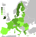
ဝှာင်:Knowledge of English EU map.svg

Size of this PNG preview of this SVG file: ၅၈၇ × ၆၀၀ pixels. အရာမသ္ဂုတ်သွာတ်လဝ်ဂမၠိုၚ်: ၂၃၅ × ၂၄၀ pixels | ၄၇၀ × ၄၈၀ pixels | ၇၅၁ × ၇၆၈ pixels | ၁၀၀၂ × ၁၀၂၄ pixels | ၂၀၀၄ × ၂၀၄၈ pixels | ၅၉၀ × ၆၀၃ pixels တၞဟ်။
ဝှာင် တမ်မူလ (SVG ဝှာင်, မိက်ကဵုကသပ် ၅၉၀ × ၆၀၃ pixels, ဇမၞော် ဝှာင်: ၆၇၁ KB)
ဝှာင် လၟေင်အပြံင်အလှာဲ
ဍဵု လတူ စၟတ်တ္ၚဲ/အခိင် မွဲမွဲ သွက်ဂွံ ထ္ၜးကဵု ဝှာင် မကတဵုဒှ်လဝ် ပ္ဍဲအခိင်ဂှ်၊၊
| စၟတ်တ္ၚဲ/အခိင် | ဗီုပြင်နမူနာ | ပမာဏ | ညးလွပ် | တင်ပသောင်ကလး | |
|---|---|---|---|---|---|
| လၟုဟ် | ၁၇:၀၆၊ ၃ ဖေဖဝ်ဝါရဳ ၂၀၂၀ |  | ၅၉၀ × ၆၀၃ (၆၇၁ KB) | Darranc | Update since UK left the EU |
| ၀၆:၀၀၊ ၁၆ ဖေဖဝ်ဝါရဳ ၂၀၁၅ |  | ၅၉၀ × ၆၀၃ (၆၇၁ KB) | Leftcry | Update layout and information | |
| ၁၈:၁၉၊ ၁၇ အံက်တဝ်ဗါ ၂၀၁၁ |  | ၁၂၁၂ × ၁၂၄၂ (၅၅၂ KB) | Treehill | deletion of Turkey, I let only candidate country with an accession date planned (Croatia and Iceland). | |
| ၁၃:၀၄၊ ၇ သေပ်တေမ်ဗါ ၂၀၁၁ |  | ၁၂၁၂ × ၁၂၄၂ (၅၅၂ KB) | Treehill | (norway was not deleted before, maybe an error) | |
| ၀၃:၂၈၊ ၇ သေပ်တေမ်ဗါ ၂၀၁၁ |  | ၁၂၁၂ × ၁၂၄၂ (၅၅၂ KB) | Treehill | deletion of Norway, as explained previously. Not an EU country (note that the name of the file is "Knowledge_of_English_EU_map.svg"). | |
| ၀၂:၂၀၊ ၇ သေပ်တေမ်ဗါ ၂၀၁၁ |  | ၁၂၁၂ × ၁၂၄၂ (၅၅၂ KB) | Treehill | I deleted Switzerland which is neither in the EU nor a candidate country. | |
| ၁၇:၄၂၊ ၁၂ ဂျူလာင် ၂၀၁၁ |  | ၁၂၁၂ × ၁၂၄၂ (၅၅၂ KB) | J intela | Added Norway and Switzerland http://en.wikipedia.org/wiki/List_of_countries_by_English-speaking_population | |
| ၀၁:၃၈၊ ၉ ဨပြဳ ၂၀၁၁ |  | ၁၂၁၂ × ၁၂၄၂ (၅၅၂ KB) | Alphathon | Improved British Isles | |
| ၀၀:၁၂၊ ၂၈ အဝ်ဂေတ် ၂၀၁၀ |  | ၁၂၁၂ × ၁၂၄၂ (၅၂၀ KB) | Alphathon | {{Information |Description={{en|1=Knowledge of English language in EU}} |Source=*File:Knowledge_of_German_EU_map.png *File:Knowledge_English_EU_map.png |Date=2010-08-27 17:41 (UTC) |Author=*File:Knowledge_of_German_EU_map.png: [[User:Her |
ဝှာင် ဗီုဂွံစကာ
မုက်လိက် မရပ်စပ် ဝှာင်ဏအ် ဟွံမဲ၊၊
ဝှာင် သွက်ဂွံသုင်စောဲ ဂလုပ်ဗဴ
ဗွဲသၟဝ်ဏအ်ဂှ် ဒှ်အရာ ဝဳကဳတၞဟ် မစကာလဝ် ဝှာင်ဏအ်၊၊
- ဗီုစကာ ပ္ဍဲ ar.wikipedia.org
- ဗီုစကာ ပ္ဍဲ ast.wikipedia.org
- ဗီုစကာ ပ္ဍဲ azb.wikipedia.org
- ဗီုစကာ ပ္ဍဲ be.wikipedia.org
- ဗီုစကာ ပ္ဍဲ ca.wikipedia.org
- ဗီုစကာ ပ္ဍဲ de.wikipedia.org
- ဗီုစကာ ပ္ဍဲ el.wikipedia.org
- ဗီုစကာ ပ္ဍဲ en.wikipedia.org
- ဗီုစကာ ပ္ဍဲ eo.wikipedia.org
- ဗီုစကာ ပ္ဍဲ es.wikipedia.org
- ဗီုစကာ ပ္ဍဲ et.wikipedia.org
- ဗီုစကာ ပ္ဍဲ fa.wikipedia.org
- ဗီုစကာ ပ္ဍဲ fi.wikipedia.org
- ဗီုစကာ ပ္ဍဲ fr.wikipedia.org
- ဗီုစကာ ပ္ဍဲ he.wikipedia.org
- ဗီုစကာ ပ္ဍဲ hu.wikipedia.org
- ဗီုစကာ ပ္ဍဲ id.wikipedia.org
- ဗီုစကာ ပ္ဍဲ it.wikipedia.org
- ဗီုစကာ ပ္ဍဲ ja.wikipedia.org
- ဗီုစကာ ပ္ဍဲ kk.wikipedia.org
- ဗီုစကာ ပ္ဍဲ lez.wikipedia.org
- ဗီုစကာ ပ္ဍဲ nl.wikipedia.org
- ဗီုစကာ ပ္ဍဲ pl.wikipedia.org
- ဗီုစကာ ပ္ဍဲ pl.wiktionary.org
- ဗီုစကာ ပ္ဍဲ roa-tara.wikipedia.org
- ဗီုစကာ ပ္ဍဲ ro.wikipedia.org
- ဗီုစကာ ပ္ဍဲ ru.wikipedia.org
- ဗီုစကာ ပ္ဍဲ sr.wikipedia.org
- ဗီုစကာ ပ္ဍဲ sv.wikipedia.org
- ဗီုစကာ ပ္ဍဲ tr.wikipedia.org
- ဗီုစကာ ပ္ဍဲ ug.wikipedia.org
ဗဵု more global usage ဝှာင်ဏအ်၊၊


