
ဝှာင်:Louisiane 1800.png
resolution ခိုဟ် နူဏအ် ဟွံဂွံဆဵုရ၊၊
Louisiane_1800.png (၃၈၃ × ၃၂၉ pixels, file size: ၉ KB, MIME type: image/png)
သကေမ်

|
This locator map image could be re-created using vector graphics as an SVG file. This has several advantages; see Commons:Media for cleanup for more information. If an SVG form of this image is available, please upload it and afterwards replace this template with
{{vector version available|new image name}}.
It is recommended to name the SVG file “Louisiane 1800.svg”—then the template Vector version available (or Vva) does not need the new image name parameter. |
| ကဵုယၟု |
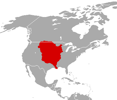
English: The Louisiana Territory as it was from 1763 to 1803.
Français : Le territoire de Louisiane tel qu'il l'était de 1763 à 1803.
Español: La Louisiana Territorio como lo fue desde 1763 a 1803. |
| စၟတ်တ္ၚဲ | |
| တမ်ရိုဟ် | File:LouisianaPurchase.png |
| ကဝိ | မသိရှိရ |
မသ္ဂုတ်သွာတ်လာင်ဇြေန်

|
လိက်တအ်ဂှ် သၠးကဵုလဝ် အခေါင် သွက်ဂွံ စၠောအ်ကပ်ပဳ၊ ပရး ကီု သီုကဵု ပလေဝ်ပခိုဟ်ပတိုန် အတိုင်သၞောတ်ဝ် GNU Free Documentation License, တုဲ မူ ၁.၂ ဟွံသေင်မ္ဂး မူတြေံနူဂှ် မတြးပတိတ် နကဵု သၞောတ်ဝ်လာင်ဇြေန် Free Software Foundation; with no Invariant Sections, no Front-Cover Texts, and no Back-Cover Texts. A copy of the license is included in the section entitled GNU Free Documentation License. |
| ဝှာင်ဏအ်ဂှ် စၟတ်သမ္တီလဝ် နကဵုလာင်ဇြေန် Creative Commons Attribution-Share Alike 3.0 Unported ရ၊၊ | ||
| ||
| This licensing tag was added to this file as part of the GFDL licensing update. |
မူရင်းတင်ထားသောမှတ်တမ်း
(All user names refer to fr.wikipedia)
- 2003-09-01 20:34 F5ZV 412×306×8 (7986 bytes) carte de la Louisiane en 1800 au moment de la vente par Napoléon aux Etats-Unis.
ဝှာင် လၟေင်အပြံင်အလှာဲ
ဍဵု လတူ စၟတ်တ္ၚဲ/အခိင် မွဲမွဲ သွက်ဂွံ ထ္ၜးကဵု ဝှာင် မကတဵုဒှ်လဝ် ပ္ဍဲအခိင်ဂှ်၊၊
| စၟတ်တ္ၚဲ/အခိင် | ဗီုပြင်နမူနာ | ပမာဏ | ညးလွပ် | တင်ပသောင်ကလး | |
|---|---|---|---|---|---|
| လၟုဟ် | ၀၇:၂၇၊ ၁၆ ဒဳဇြေမ်ဗါ ၂၀၁၀ | | ၃၈၃ × ၃၂၉ (၉ KB) | Maps & Lucy | fixed the border along New Spain and changed colour to Spanish Red due to it being a territory of New Spain |
| ၂၁:၄၄၊ ၁၈ အဝ်ဂေတ် ၂၀၁၀ |  | ၃၈၃ × ၃၂၉ (၉ KB) | Maps & Lucy | {{Information |Description=''English:'' The Louisiana Territory as it was from 1763 to 1803. <br> ''Français:'' La Louisiane territoire comme il a été de 1763 à 1803. <br> ''Español:'' La Louisiana Territorio como lo fue desde 1763 a 1803. |Source=[[ | |
| ၁၇:၅၃၊ ၂၉ ဇာန်နဝါရဳ ၂၀၀၇ |  | ၄၁၂ × ၃၀၆ (၈ KB) | Bilou~commonswiki | {{Information |Description=carte de la Louisiane en 1800 au moment de la vente par Napoléon aux États-Unis. |Source=Dessinée par F5ZV |Date=2003-09-01 (original upload date) |Author=F5ZV at [http://fr.wikipedi |
ဝှာင် ဗီုဂွံစကာ
မုက်လိက် မရပ်စပ် ဝှာင်ဏအ် ဟွံမဲ၊၊
ဝှာင် သွက်ဂွံသုင်စောဲ ဂလုပ်ဗဴ
ဗွဲသၟဝ်ဏအ်ဂှ် ဒှ်အရာ ဝဳကဳတၞဟ် မစကာလဝ် ဝှာင်ဏအ်၊၊
- ဗီုစကာ ပ္ဍဲ ar.wikipedia.org
- ဗီုစကာ ပ္ဍဲ de.wikipedia.org
- ဗီုစကာ ပ္ဍဲ en.wikipedia.org
- ဗီုစကာ ပ္ဍဲ eo.wikipedia.org
- ဗီုစကာ ပ္ဍဲ et.wikipedia.org
- ဗီုစကာ ပ္ဍဲ fr.wikipedia.org
- ဗီုစကာ ပ္ဍဲ it.wikipedia.org
- ဗီုစကာ ပ္ဍဲ ja.wikipedia.org
- ဗီုစကာ ပ္ဍဲ ko.wikipedia.org
- ဗီုစကာ ပ္ဍဲ mg.wikipedia.org
- ဗီုစကာ ပ္ဍဲ pcd.wikipedia.org
- ဗီုစကာ ပ္ဍဲ pt.wikipedia.org