
ဝှာင်:Malvern Hills - England.jpg

ဇမၞော် နမူနာ ဏအ် - ၈၀၀ × ၄၆၄ pixels အရာမသ္ဂုတ်သွာတ်လဝ်ဂမၠိုၚ်: ၃၂၀ × ၁၈၅ pixels | ၆၄၀ × ၃၇၁ pixels | ၁၀၂၄ × ၅၉၄ pixels | ၁၂၈၀ × ၇၄၂ pixels | ၂၅၆၀ × ၁၄၈၄ pixels | ၃၆၅၆ × ၂၁၁၉ pixels တၞဟ်။
ဝှာင် တမ်မူလ (၃၆၅၆ × ၂၁၁၉ pixels, file size: ၂.၄၁ MB, MIME type: image/jpeg)
သကေမ်
| ကဵုယၟု |
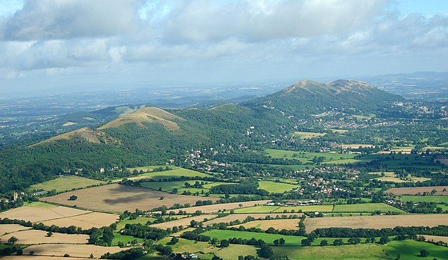
English: The Malvern Hills located in the English counties of Worcestershire and Herefordshire. The hills have been designated by the Countryside Agency as an Area of Outstanding Natural Beauty. The highest point is the Worcestershire Beacon at 425 metres (1,394 ft) above sea level. The range is a natural border between Worcestershire and Herefordshire. |
| စၟတ်တ္ၚဲ | |
| တမ်ရိုဟ် |
https://www.flickr.com/photos/davidchief/2765256316/
|
| ကဝိ | David Martyn Hunt |
| Camera location | | View this and other nearby images on: OpenStreetMap |
|---|
မသ္ဂုတ်သွာတ်လာင်ဇြေန်
| This image, originally posted to Flickr, was reviewed on 4 March 2012 by the administrator or reviewer Materialscientist, who confirmed that it was available on Flickr under the stated license on that date. |
ဤဖိုင်သည် Creative Commons Attribution 2.0 Generic လိုင်စင်အောက်တွင် လိုင်စင်သတ်မှတ်ထားပါသည်။
- မၞးဂှ် ဗွဲမဗၠးၜး -
- သွက်ဂွံ ပါ်ပရအ် – သွက်ဂွံ စၠောအ်ပပ်ပဳ၊ တြးပတိတ်၊ ဗလး ကမၠောန်
- သွက်ဂွံ ပကောံနှဴ – သွက်ဂွံ ပလေဝ်ပညဳ ကမၠောန်
- နကဵု တင်မသ္ဒးဒ္ဂေတ်ဗက် ဗွဲသၟဝ်ဏအ်ဂှ်
- တင်မစှ်ေစိုတ် – မၞး သ္ဒးဒ္ဂေတ်ဗက် သၞောတ်ဝ် မဖျေဟ်လဝ် စပ်ကဵု အစာချူလိက် ဟွံသေင်မ္ဂး တၠမူတအ်ရောင်၊၊ (ဆဂး နကဵုနဲလဵု အကာဲအရာ ဗီုလဵုလေဝ် ဟွံကဵုကသပ် ဟွံထံက်ဂလာန် ကုမၞး ပ္ဍဲအရာမစကာ ဒြပ်ညးတၞဟ်တအ်ရောင်)။
| Annotations | This image is annotated: View the annotations at Commons |

|
This image has been assessed under the valued image criteria and is considered the most valued image on Commons within the scope: Malvern Hills, England. You can see its nomination here. |
ဝှာင် လၟေင်အပြံင်အလှာဲ
ဍဵု လတူ စၟတ်တ္ၚဲ/အခိင် မွဲမွဲ သွက်ဂွံ ထ္ၜးကဵု ဝှာင် မကတဵုဒှ်လဝ် ပ္ဍဲအခိင်ဂှ်၊၊
| စၟတ်တ္ၚဲ/အခိင် | ဗီုပြင်နမူနာ | ပမာဏ | ညးလွပ် | တင်ပသောင်ကလး | |
|---|---|---|---|---|---|
| လၟုဟ် | ၂၃:၁၁၊ ၂၄ ဨပြဳ ၂၀၂၃ | | ၃၆၅၆ × ၂၁၁၉ (၂.၄၁ MB) | Artanisen | Highest quality (same source) |
| ၁၉:၂၃၊ ၄ မာတ် ၂၀၁၂ |  | ၁၀၀၃ × ၅၇၇ (၆၀၃ KB) | MrPanyGoff | cropped blown clouds | |
| ၁၉:၀၅၊ ၄ မာတ် ၂၀၁၂ |  | ၁၀၀၃ × ၆၅၈ (၆၃၅ KB) | MrPanyGoff |
ဝှာင် ဗီုဂွံစကာ
မုက်လိက် မရပ်စပ် ဝှာင်ဏအ် ဟွံမဲ၊၊
ဝှာင် သွက်ဂွံသုင်စောဲ ဂလုပ်ဗဴ
ဗွဲသၟဝ်ဏအ်ဂှ် ဒှ်အရာ ဝဳကဳတၞဟ် မစကာလဝ် ဝှာင်ဏအ်၊၊
- ဗီုစကာ ပ္ဍဲ arz.wikipedia.org
- ဗီုစကာ ပ္ဍဲ ceb.wikipedia.org
- ဗီုစကာ ပ္ဍဲ de.wikipedia.org
- ဗီုစကာ ပ္ဍဲ de.wikivoyage.org
- ဗီုစကာ ပ္ဍဲ en.wikipedia.org
- ဗီုစကာ ပ္ဍဲ en.wikivoyage.org
- ဗီုစကာ ပ္ဍဲ fa.wikipedia.org
- ဗီုစကာ ပ္ဍဲ fr.wikipedia.org
- ဗီုစကာ ပ္ဍဲ he.wikipedia.org
- ဗီုစကာ ပ္ဍဲ io.wikipedia.org
- ဗီုစကာ ပ္ဍဲ is.wikipedia.org
- ဗီုစကာ ပ္ဍဲ it.wikivoyage.org
- ဗီုစကာ ပ္ဍဲ mg.wikipedia.org
- ဗီုစကာ ပ္ဍဲ pl.wikipedia.org
- ဗီုစကာ ပ္ဍဲ tr.wikipedia.org
- ဗီုစကာ ပ္ဍဲ www.wikidata.org
- ဗီုစကာ ပ္ဍဲ zh.wikipedia.org