
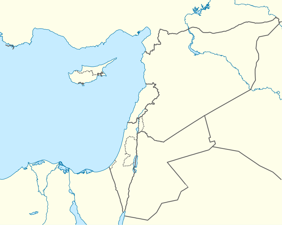
ဝှာင်:Mediterranean Sea East location map.svg

ဝှာင် တမ်မူလ (SVG ဝှာင်, မိက်ကဵုကသပ် ၉၅၇ × ၇၆၅ pixels, ဇမၞော် ဝှာင်: ၁၈၆ KB)
သကေမ်
| ကဵုယၟု |
Deutsch: Positionskarte des östlichen Mittelmeers
Quadratische Plattkarte, N-S-Streckung 120 %. Geographische Begrenzung der Karte:
English: Location map of the Eastern Mediterranean Sea
Equirectangular projection, N/S stretching 120 %. Geographic limits of the map:
|
|
| စၟတ်တ္ၚဲ | ||
| တမ်ရိုဟ် | Own work using: World Data Base II data | |
| ကဝိ | NordNordWest | |
| တင်မကဵုအခေါင် (ကလေင်သုင်စောဲ ဝှာင်ဏအ်) |
ဤဖိုင်သည် Creative Commons Attribution-Share Alike 3.0 ဂျာမနီ လိုင်စင်အောက်တွင် လိုင်စင်သတ်မှတ်ထားပါသည်။
 |


|
This map has been made or improved in the German Kartenwerkstatt (Map Lab). You can propose maps to improve as well.
|
မသ္ဂုတ်သွာတ်လာင်ဇြေန်
- မၞးဂှ် ဗွဲမဗၠးၜး -
- သွက်ဂွံ ပါ်ပရအ် – သွက်ဂွံ စၠောအ်ပပ်ပဳ၊ တြးပတိတ်၊ ဗလး ကမၠောန်
- သွက်ဂွံ ပကောံနှဴ – သွက်ဂွံ ပလေဝ်ပညဳ ကမၠောန်
- နကဵု တင်မသ္ဒးဒ္ဂေတ်ဗက် ဗွဲသၟဝ်ဏအ်ဂှ်
- တင်မစှ်ေစိုတ် – မၞး သ္ဒးဒ္ဂေတ်ဗက် သၞောတ်ဝ် မဖျေဟ်လဝ် စပ်ကဵု အစာချူလိက် ဟွံသေင်မ္ဂး တၠမူတအ်ရောင်၊၊ (ဆဂး နကဵုနဲလဵု အကာဲအရာ ဗီုလဵုလေဝ် ဟွံကဵုကသပ် ဟွံထံက်ဂလာန် ကုမၞး ပ္ဍဲအရာမစကာ ဒြပ်ညးတၞဟ်တအ်ရောင်)။
- ပါ်ပရအ် အရာမတုပ်သၟဟ် – ယဝ်ရ မၞး ပလေဝ်၊ ပြံင်လှာဲ ဟွံသေင်မ္ဂး ထပ်ခၞံဗဒှ်တၟိမ္ဂး အရာကမၠောန်တအ် သီုဖအိုတ်ဂှ် သ္ဒးပရးပတိတ် နကဵုသၟဝ် မတုပ် ဟွံသေင်မ္ဂး မသၟဟ် ကုလာင်ဇြေန် ကမၠောန်တြေံဂှ် ဟေင်ရ၊၊
ဝှာင် လၟေင်အပြံင်အလှာဲ
ဍဵု လတူ စၟတ်တ္ၚဲ/အခိင် မွဲမွဲ သွက်ဂွံ ထ္ၜးကဵု ဝှာင် မကတဵုဒှ်လဝ် ပ္ဍဲအခိင်ဂှ်၊၊
| စၟတ်တ္ၚဲ/အခိင် | ဗီုပြင်နမူနာ | ပမာဏ | ညးလွပ် | တင်ပသောင်ကလး | |
|---|---|---|---|---|---|
| လၟုဟ် | ၂၃:၅၈၊ ၃ ဨပြဳ ၂၀၁၃ | | ၉၅၇ × ၇၆၅ (၁၈၆ KB) | NordNordWest | =={{int:filedesc}}== {{Information |Description= {{de|Positionskarte des östlichen Mittelmeers}} Quadratische Plattkarte, N-S-Streckung 120 %. Geographische Begrenzung der Karte: * N: 38.0° N * S: 29.0° N * W: 29.0° O * O: 42.5°... |
ဝှာင် ဗီုဂွံစကာ
မုက်လိက် မရပ်စပ် ဝှာင်ဏအ် ဟွံမဲ၊၊
ဝှာင် သွက်ဂွံသုင်စောဲ ဂလုပ်ဗဴ
ဗွဲသၟဝ်ဏအ်ဂှ် ဒှ်အရာ ဝဳကဳတၞဟ် မစကာလဝ် ဝှာင်ဏအ်၊၊
- ဗီုစကာ ပ္ဍဲ ast.wikipedia.org
- Episkopí
- Acrotiri (pueblu)
- Nicosia
- Limasol
- Famagusta
- Módulu:Mapa de llocalización/datos/Xipre
- Módulu:Mapa de llocalización/datos/Xipre/usu
- Aeropuertu Internacional de Lárnaca
- Aeropuertu Internacional de Pafos
- Aeropuertu d'Ercan
- Aeropuertu de Nicosia
- Base Aérea de Geçitkale
- Puertu de Limasol
- Pelendri
- Kantou
- Mouttagiaka
- Paramali
- Platres
- Pano Polemidia
- Kato Kivides
- Pissouri
- Omodos
- Platanisteia
- Kolossi
- Kyperounta
- Foini
- Pachna
- Palodia
- Palaiomylos
- Pera Pedi
- Monagroulli
- Paramytha
- Pentakomo
- Parekklisia
- Moniatis
- Prastio (Avdimou)
- Potamitissa
- Potamiou
- Asgata
- Prodromos
- Trachoni
- Vouni
- Armenokhori
- Vikla
- Vasa Koilaniou
- Vasa Kellakiou
- Tserkezoi
- Trimiklini
- Treis Elies
- Sykopetra
ဗဵု more global usage ဝှာင်ဏအ်၊၊