
ဝှာင်:Michigan-territory-1836.png
resolution ခိုဟ် နူဏအ် ဟွံဂွံဆဵုရ၊၊
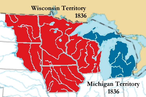
Michigan-territory-1836.png (၄၆၉ × ၃၁၁ pixels, file size: ၈၅ KB, MIME type: image/png)
သကေမ်
The image was transferred from en.wiki (en:Image:Michigan-territory-1836.png) under the {{GFDL-en}} + {{Cc-by-2.0-map}} license tags. Wars 06:35, 16 May 2007 (UTC)
| ကဵုယၟု | Map of Michigan Territory in 1836 following the detachment of Wisconsin Territory Based on a public domain U.S. government map. | ||
| စၟတ်တ္ၚဲ | |||
| တမ်ရိုဟ် | English Wikipedia | ||
| ကဝိ | Jengod | ||
| တင်မကဵုအခေါင် (ကလေင်သုင်စောဲ ဝှာင်ဏအ်) |
ဤဖိုင်သည် Creative Commons Attribution 2.0 Generic လိုင်စင်အောက်တွင် လိုင်စင်သတ်မှတ်ထားပါသည်။
|

မသ္ဂုတ်သွာတ်လာင်ဇြေန်
ကျွန်ုပ်၊ ဤလုပ်ဆောင်ချက်၏ မူပိုင်ခွင့်ပိုင်ရှင်အနေဖြင့် ဤနေရာမှ အောက်ပါလိုင်စင်များအောက်တွင် ထုတ်လွှင့်ပါသည်:

|
လိက်တအ်ဂှ် သၠးကဵုလဝ် အခေါင် သွက်ဂွံ စၠောအ်ကပ်ပဳ၊ ပရး ကီု သီုကဵု ပလေဝ်ပခိုဟ်ပတိုန် အတိုင်သၞောတ်ဝ် GNU Free Documentation License, တုဲ မူ ၁.၂ ဟွံသေင်မ္ဂး မူတြေံနူဂှ် မတြးပတိတ် နကဵု သၞောတ်ဝ်လာင်ဇြေန် Free Software Foundation; with no Invariant Sections, no Front-Cover Texts, and no Back-Cover Texts. A copy of the license is included in the section entitled GNU Free Documentation License. |
| ဝှာင်ဏအ်ဂှ် စၟတ်သမ္တီလဝ် နကဵုလာင်ဇြေန် Creative Commons Attribution-Share Alike 3.0 Unported ရ၊၊ | ||
| ||
| This licensing tag was added to this file as part of the GFDL licensing update. |
ဤဖိုင်သည် Creative Commons Attribution-Share Alike 2.5 Generic, 2.0 Generic and 1.0 Generic လိုင်စင်အောက်တွင် လိုင်စင်သတ်မှတ်ထားပါသည်။
- မၞးဂှ် ဗွဲမဗၠးၜး -
- သွက်ဂွံ ပါ်ပရအ် – သွက်ဂွံ စၠောအ်ပပ်ပဳ၊ တြးပတိတ်၊ ဗလး ကမၠောန်
- သွက်ဂွံ ပကောံနှဴ – သွက်ဂွံ ပလေဝ်ပညဳ ကမၠောန်
- နကဵု တင်မသ္ဒးဒ္ဂေတ်ဗက် ဗွဲသၟဝ်ဏအ်ဂှ်
- တင်မစှ်ေစိုတ် – မၞး သ္ဒးဒ္ဂေတ်ဗက် သၞောတ်ဝ် မဖျေဟ်လဝ် စပ်ကဵု အစာချူလိက် ဟွံသေင်မ္ဂး တၠမူတအ်ရောင်၊၊ (ဆဂး နကဵုနဲလဵု အကာဲအရာ ဗီုလဵုလေဝ် ဟွံကဵုကသပ် ဟွံထံက်ဂလာန် ကုမၞး ပ္ဍဲအရာမစကာ ဒြပ်ညးတၞဟ်တအ်ရောင်)။
- ပါ်ပရအ် အရာမတုပ်သၟဟ် – ယဝ်ရ မၞး ပလေဝ်၊ ပြံင်လှာဲ ဟွံသေင်မ္ဂး ထပ်ခၞံဗဒှ်တၟိမ္ဂး အရာကမၠောန်တအ် သီုဖအိုတ်ဂှ် သ္ဒးပရးပတိတ် နကဵုသၟဝ် မတုပ် ဟွံသေင်မ္ဂး မသၟဟ် ကုလာင်ဇြေန် ကမၠောန်တြေံဂှ် ဟေင်ရ၊၊
လာင်ဇြေန် မၞး မၞုံပၟိက်ဂှ် မၞးရုဲစှ်ကေတ် မာန်ရ၊၊
ဝှာင် လၟေင်အပြံင်အလှာဲ
ဍဵု လတူ စၟတ်တ္ၚဲ/အခိင် မွဲမွဲ သွက်ဂွံ ထ္ၜးကဵု ဝှာင် မကတဵုဒှ်လဝ် ပ္ဍဲအခိင်ဂှ်၊၊
| စၟတ်တ္ၚဲ/အခိင် | ဗီုပြင်နမူနာ | ပမာဏ | ညးလွပ် | တင်ပသောင်ကလး | |
|---|---|---|---|---|---|
| လၟုဟ် | ၀၃:၅၅၊ ၁ ဂျူလာင် ၂၀၀၈ | | ၄၆၉ × ၃၁၁ (၈၅ KB) | Thatoneguy89 | {{Information |Description=Map of en:Michigan Territory in 1836 following the detachment of Wisconsin Territory; created October 2004 by Jengod. Based on a public domain U.S. government map. |Source= English Wikipedia |Date |
| ၁၃:၀၅၊ ၁၆ မေ ၂၀၀၇ |  | ၄၆၉ × ၃၁၁ (၈၅ KB) | Wars | == Summary == The image was transferred from en.wiki (en:Image:Michigan-territory-1836.png) under the '''<nowiki>{{GFDL-with-disclaimers}} + {{Cc-by-2.0-map}}</nowiki>''' license tags. ~~~~ {{Information |Description = Map of [[:en:Michi |
ဝှာင် ဗီုဂွံစကာ
မုက်လိက် မရပ်စပ် ဝှာင်ဏအ် ဟွံမဲ၊၊
ဝှာင် သွက်ဂွံသုင်စောဲ ဂလုပ်ဗဴ
ဗွဲသၟဝ်ဏအ်ဂှ် ဒှ်အရာ ဝဳကဳတၞဟ် မစကာလဝ် ဝှာင်ဏအ်၊၊
- ဗီုစကာ ပ္ဍဲ ca.wikipedia.org
- ဗီုစကာ ပ္ဍဲ cs.wikipedia.org
- ဗီုစကာ ပ္ဍဲ de.wikipedia.org
- ဗီုစကာ ပ္ဍဲ en.wikipedia.org
- ဗီုစကာ ပ္ဍဲ es.wikipedia.org
- ဗီုစကာ ပ္ဍဲ fr.wikipedia.org
- ဗီုစကာ ပ္ဍဲ he.wikipedia.org
- ဗီုစကာ ပ္ဍဲ ja.wikipedia.org
- ဗီုစကာ ပ္ဍဲ ka.wikipedia.org
- ဗီုစကာ ပ္ဍဲ ko.wikipedia.org
- ဗီုစကာ ပ္ဍဲ no.wikipedia.org
- ဗီုစကာ ပ္ဍဲ pt.wikipedia.org
- ဗီုစကာ ပ္ဍဲ ro.wikipedia.org
- ဗီုစကာ ပ္ဍဲ ru.wikipedia.org
- ဗီုစကာ ပ္ဍဲ sv.wikipedia.org
- ဗီုစကာ ပ္ဍဲ vi.wikipedia.org
- ဗီုစကာ ပ္ဍဲ zh.wikipedia.org