
ဝှာင်:Mournes wiki.jpg

ဇမၞော် နမူနာ ဏအ် - ၈၀၀ × ၄၁၉ pixels အရာမသ္ဂုတ်သွာတ်လဝ်ဂမၠိုၚ်: ၃၂၀ × ၁၆၈ pixels | ၆၄၀ × ၃၃၅ pixels | ၁၀၂၄ × ၅၃၆ pixels | ၁၂၈၀ × ၆၇၀ pixels | ၂၈၀၂ × ၁၄၆၇ pixels တၞဟ်။
ဝှာင် တမ်မူလ (၂၈၀၂ × ၁၄၆၇ pixels, file size: ၄၀၈ KB, MIME type: image/jpeg)
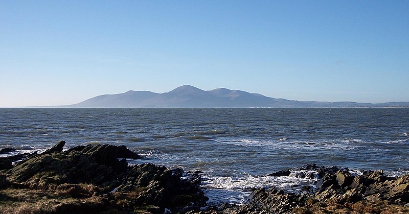
View of the Mountains of Mourne from St. John's Point, County Down. Slieve Donard, the highest mountain in Northern Ireland, is in the centre.
Photo taken by Mark83, 14 January 2006

|
လိက်တအ်ဂှ် သၠးကဵုလဝ် အခေါင် သွက်ဂွံ စၠောအ်ကပ်ပဳ၊ ပရး ကီု သီုကဵု ပလေဝ်ပခိုဟ်ပတိုန် အတိုင်သၞောတ်ဝ် GNU Free Documentation License, တုဲ မူ ၁.၂ ဟွံသေင်မ္ဂး မူတြေံနူဂှ် မတြးပတိတ် နကဵု သၞောတ်ဝ်လာင်ဇြေန် Free Software Foundation; with no Invariant Sections, no Front-Cover Texts, and no Back-Cover Texts. A copy of the license is included in the section entitled GNU Free Documentation License. |
| ဝှာင်ဏအ်ဂှ် စၟတ်သမ္တီလဝ် နကဵုလာင်ဇြေန် Creative Commons Attribution-Share Alike 3.0 Unported ရ၊၊ | ||
| ||
| This licensing tag was added to this file as part of the GFDL licensing update. |
| Camera location | | View this and other nearby images on: OpenStreetMap |
|---|
ဝှာင် လၟေင်အပြံင်အလှာဲ
ဍဵု လတူ စၟတ်တ္ၚဲ/အခိင် မွဲမွဲ သွက်ဂွံ ထ္ၜးကဵု ဝှာင် မကတဵုဒှ်လဝ် ပ္ဍဲအခိင်ဂှ်၊၊
| စၟတ်တ္ၚဲ/အခိင် | ဗီုပြင်နမူနာ | ပမာဏ | ညးလွပ် | တင်ပသောင်ကလး | |
|---|---|---|---|---|---|
| လၟုဟ် | ၂၃:၂၄၊ ၂ အံက်တဝ်ဗါ ၂၀၀၆ | | ၂၈၀၂ × ၁၄၆၇ (၄၀၈ KB) | Voyager | View of the Mountains of Mourne from St. John's Point, County Down. Slieve Donard, the highest mountain in Northern Ireland, is in the centre. Photo taken by Mark83, 14 January 2006 {{GFDL}} Category:Mountains of Ireland |
ဝှာင် ဗီုဂွံစကာ
မုက်လိက် မရပ်စပ် ဝှာင်ဏအ် ဟွံမဲ၊၊
ဝှာင် သွက်ဂွံသုင်စောဲ ဂလုပ်ဗဴ
ဗွဲသၟဝ်ဏအ်ဂှ် ဒှ်အရာ ဝဳကဳတၞဟ် မစကာလဝ် ဝှာင်ဏအ်၊၊
- ဗီုစကာ ပ္ဍဲ af.wikipedia.org
- ဗီုစကာ ပ္ဍဲ ar.wikipedia.org
- ဗီုစကာ ပ္ဍဲ arz.wikipedia.org
- ဗီုစကာ ပ္ဍဲ ceb.wikipedia.org
- ဗီုစကာ ပ္ဍဲ cy.wikipedia.org
- ဗီုစကာ ပ္ဍဲ de.wikipedia.org
- ဗီုစကာ ပ္ဍဲ de.wikivoyage.org
- ဗီုစကာ ပ္ဍဲ en.wikipedia.org
- ဗီုစကာ ပ္ဍဲ en.wikivoyage.org
- ဗီုစကာ ပ္ဍဲ eu.wikipedia.org
- ဗီုစကာ ပ္ဍဲ fa.wikipedia.org
- ဗီုစကာ ပ္ဍဲ fr.wikipedia.org
- ဗီုစကာ ပ္ဍဲ ga.wikipedia.org
- ဗီုစကာ ပ္ဍဲ he.wikivoyage.org
- ဗီုစကာ ပ္ဍဲ it.wikipedia.org
- ဗီုစကာ ပ္ဍဲ it.wikivoyage.org
- ဗီုစကာ ပ္ဍဲ ja.wikipedia.org
- ဗီုစကာ ပ္ဍဲ ko.wikipedia.org
- ဗီုစကာ ပ္ဍဲ lt.wikipedia.org
- ဗီုစကာ ပ္ဍဲ mk.wikipedia.org
- ဗီုစကာ ပ္ဍဲ nl.wikipedia.org
- ဗီုစကာ ပ္ဍဲ nn.wikipedia.org
- ဗီုစကာ ပ္ဍဲ no.wikipedia.org
- ဗီုစကာ ပ္ဍဲ pl.wikipedia.org
- ဗီုစကာ ပ္ဍဲ ru.wikipedia.org
- ဗီုစကာ ပ္ဍဲ sv.wikipedia.org
- ဗီုစကာ ပ္ဍဲ tr.wikipedia.org
- ဗီုစကာ ပ္ဍဲ vi.wikipedia.org
- ဗီုစကာ ပ္ဍဲ www.wikidata.org