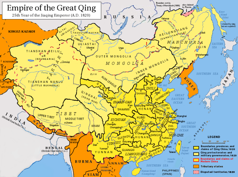
ဝှာင်:Qing Dynasty 1820.png

ဇမၞော် နမူနာ ဏအ် - ၈၀၀ × ၅၉၃ pixels အရာမသ္ဂုတ်သွာတ်လဝ်ဂမၠိုၚ်: ၃၂၀ × ၂၃၇ pixels | ၆၄၀ × ၄၇၅ pixels | ၉၁၀ × ၆၇၅ pixels တၞဟ်။
ဝှာင် တမ်မူလ (၉၁၀ × ၆၇၅ pixels, file size: ၃၉၈ KB, MIME type: image/png)
ဝှာင် လၟေင်အပြံင်အလှာဲ
ဍဵု လတူ စၟတ်တ္ၚဲ/အခိင် မွဲမွဲ သွက်ဂွံ ထ္ၜးကဵု ဝှာင် မကတဵုဒှ်လဝ် ပ္ဍဲအခိင်ဂှ်၊၊
| စၟတ်တ္ၚဲ/အခိင် | ဗီုပြင်နမူနာ | ပမာဏ | ညးလွပ် | တင်ပသောင်ကလး | |
|---|---|---|---|---|---|
| လၟုဟ် | ၁၁:၄၅၊ ၁၇ မေ ၂၀၁၄ |  | ၉၁၀ × ၆၇၅ (၃၉၈ KB) | Tenohira | fix |
| ၁၁:၀၂၊ ၁၇ မေ ၂၀၁၄ |  | ၉၁၀ × ၆၇၅ (၄၀၁ KB) | Benlisquare | rev: per the guideline page at Commons:Overwriting existing files, you should be creating a fork file, not overwriting this existing one | |
| ၀၇:၁၈၊ ၁၇ မေ ၂၀၁၄ |  | ၉၁၀ × ၆၇၅ (၃၉၄ KB) | Tenohira | remove "nine-dotted line" https://en.wikipedia.org/wiki/File_talk:Qing_Dynasty_1820.png | |
| ၀၆:၂၉၊ ၁၇ မေ ၂၀၁၄ |  | ၉၁၀ × ၆၇၅ (၃၇၂ KB) | Tenohira | original | |
| ၀၄:၂၂၊ ၂၀ ဒဳဇြေမ်ဗါ ၂၀၁၂ |  | ၉၁၀ × ၆၇၅ (၄၀၁ KB) | Pryaltonian~commonswiki | Adjusted map to be more in line with contemporary-Qing maps, with references also from late-Qing and Republican China. | |
| ၂၂:၀၅၊ ၂၂ သေပ်တေမ်ဗါ ၂၀၁၁ |  | ၉၁၀ × ၆၇၅ (၃၈၀ KB) | Pryaltonian~commonswiki | Only southern Palawan was part of the Borneo and then Sulu sultanates, until Spanish annexation of Sulu in 1851. | |
| ၂၁:၄၀၊ ၂၁ သေပ်တေမ်ဗါ ၂၀၁၁ |  | ၉၁၀ × ၆၇၅ (၃၈၀ KB) | Pryaltonian~commonswiki | Modified to distinguish between provinces, military governorates, and protectorates. Tributary states also added. | |
| ၁၀:၁၈၊ ၂၂ ဂျောန် ၂၀၁၀ |  | ၉၁၀ × ၆၇၅ (၃၅၅ KB) | Benlisquare | Revert - redraw the map yourself. MS Paint overlaying of a corner is an eyesore. Illogical to have the title repeated twice. | |
| ၀၄:၁၆၊ ၂၂ ဂျောန် ၂၀၁၀ |  | ၉၁၀ × ၆၇၅ (၃၈၆ KB) | Hisacw | rv to NPOVify: the status on certain outlier islands (e.g. Sakhalin) is not explicitly defined, c.f. the map [http://go-passport.grolier.com/map?id=mh00032&pid=go] | |
| ၁၂:၂၉၊ ၂၀ ဂျောန် ၂၀၁၀ |  | ၉၁၀ × ၆၇၅ (၃၅၅ KB) | Benlisquare | Reverted to version as of 19:58, 27 September 2008 |
ဝှာင် ဗီုဂွံစကာ
မုက်လိက် မရပ်စပ် ဝှာင်ဏအ် ဟွံမဲ၊၊
ဝှာင် သွက်ဂွံသုင်စောဲ ဂလုပ်ဗဴ
ဗွဲသၟဝ်ဏအ်ဂှ် ဒှ်အရာ ဝဳကဳတၞဟ် မစကာလဝ် ဝှာင်ဏအ်၊၊
- ဗီုစကာ ပ္ဍဲ als.wikipedia.org
- ဗီုစကာ ပ္ဍဲ an.wikipedia.org
- ဗီုစကာ ပ္ဍဲ ar.wikipedia.org
- ဗီုစကာ ပ္ဍဲ azb.wikipedia.org
- ဗီုစကာ ပ္ဍဲ az.wikipedia.org
- ဗီုစကာ ပ္ဍဲ bat-smg.wikipedia.org
- ဗီုစကာ ပ္ဍဲ ba.wikipedia.org
- ဗီုစကာ ပ္ဍဲ be-tarask.wikipedia.org
- ဗီုစကာ ပ္ဍဲ be.wikipedia.org
- ဗီုစကာ ပ္ဍဲ bg.wikipedia.org
- ဗီုစကာ ပ္ဍဲ cs.wikipedia.org
- ဗီုစကာ ပ္ဍဲ da.wikipedia.org
- ဗီုစကာ ပ္ဍဲ de.wikipedia.org
- ဗီုစကာ ပ္ဍဲ en.wikipedia.org
- Qing dynasty
- History of Taiwan
- Inner Mongolia
- Administrative divisions of China
- Zhili
- Talk:History of the administrative divisions of China before 1912
- Tannu Uriankhai
- User:Pryaltonian
- Portal:Taiwan
- Taiwan under Qing rule
- User:Eumolpus214
- Talk:Qing dynasty/Archive 3
- History of Tuva
- Senkaku Islands dispute
- Tributary system of China
- Talk:Chinese civilization/Archive 26
- Talk:Qing dynasty/Archive 5
- Qing dynasty in Inner Asia
- Timeline of the Qing dynasty
- Timeline of Yunnan-Guizhou
- Talk:History of Xinjiang/Archive 1
- User:Falcaorib
- Administration of territory in dynastic China
- Government of the Qing dynasty
- User:SilverStar54/Administrative divisions of China
- Wikipedia:Reference desk/Archives/Humanities/2023 July 15
- ဗီုစကာ ပ္ဍဲ es.wikipedia.org
ဗဵု more global usage ဝှာင်ဏအ်၊၊


