
ဝှာင်:Scotland 1974 Administrative Map.png

ဇမၞော် နမူနာ ဏအ် - ၃၄၅ × ၆၀၀ pixels အရာမသ္ဂုတ်သွာတ်လဝ်ဂမၠိုၚ်: ၁၃၈ × ၂၄၀ pixels | ၂၇၆ × ၄၈၀ pixels | ၄၄၂ × ၇၆၈ pixels | ၅၈၉ × ၁၀၂၄ pixels | ၂၀၀၀ × ၃၄၇၆ pixels တၞဟ်။
ဝှာင် တမ်မူလ (၂၀၀၀ × ၃၄၇၆ pixels, file size: ၁.၄၂ MB, MIME type: image/png)
သကေမ်
| ကဵုယၟု |
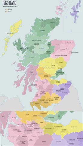
English: Administrative map of Scotland in 1974 showing the reforms of the Local Government Act (Scotland) 1973 |
| စၟတ်တ္ၚဲ | |
| တမ်ရိုဟ် | ကမၠောန် ဇကုအပိုင် |
| ကဝိ | XrysD |
မသ္ဂုတ်သွာတ်လာင်ဇြေန်
ကျွန်ုပ်၊ ဤလုပ်ဆောင်ချက်၏ မူပိုင်ခွင့်ပိုင်ရှင်အနေဖြင့် ဤနေရာမှ အောက်ပါလိုင်စင်အောက်တွင် ထုတ်လွှင့်ပါသည်:
ဝှာင်ဏအ်ဂှ် စၟတ်သမ္တီလဝ် နကဵုလာင်ဇြေန် Creative Commons Attribution-Share Alike 3.0 Unported ရ၊၊
- မၞးဂှ် ဗွဲမဗၠးၜး -
- သွက်ဂွံ ပါ်ပရအ် – သွက်ဂွံ စၠောအ်ပပ်ပဳ၊ တြးပတိတ်၊ ဗလး ကမၠောန်
- သွက်ဂွံ ပကောံနှဴ – သွက်ဂွံ ပလေဝ်ပညဳ ကမၠောန်
- နကဵု တင်မသ္ဒးဒ္ဂေတ်ဗက် ဗွဲသၟဝ်ဏအ်ဂှ်
- တင်မစှ်ေစိုတ် – မၞး သ္ဒးဒ္ဂေတ်ဗက် သၞောတ်ဝ် မဖျေဟ်လဝ် စပ်ကဵု အစာချူလိက် ဟွံသေင်မ္ဂး တၠမူတအ်ရောင်၊၊ (ဆဂး နကဵုနဲလဵု အကာဲအရာ ဗီုလဵုလေဝ် ဟွံကဵုကသပ် ဟွံထံက်ဂလာန် ကုမၞး ပ္ဍဲအရာမစကာ ဒြပ်ညးတၞဟ်တအ်ရောင်)။
- ပါ်ပရအ် အရာမတုပ်သၟဟ် – ယဝ်ရ မၞး ပလေဝ်၊ ပြံင်လှာဲ ဟွံသေင်မ္ဂး ထပ်ခၞံဗဒှ်တၟိမ္ဂး အရာကမၠောန်တအ် သီုဖအိုတ်ဂှ် သ္ဒးပရးပတိတ် နကဵုသၟဝ် မတုပ် ဟွံသေင်မ္ဂး မသၟဟ် ကုလာင်ဇြေန် ကမၠောန်တြေံဂှ် ဟေင်ရ၊၊
ဝှာင် လၟေင်အပြံင်အလှာဲ
ဍဵု လတူ စၟတ်တ္ၚဲ/အခိင် မွဲမွဲ သွက်ဂွံ ထ္ၜးကဵု ဝှာင် မကတဵုဒှ်လဝ် ပ္ဍဲအခိင်ဂှ်၊၊
| စၟတ်တ္ၚဲ/အခိင် | ဗီုပြင်နမူနာ | ပမာဏ | ညးလွပ် | တင်ပသောင်ကလး | |
|---|---|---|---|---|---|
| လၟုဟ် | ၁၅:၁၉၊ ၁၉ ဂျူလာင် ၂၀၂၀ | | ၂၀၀၀ × ၃၄၇၆ (၁.၄၂ MB) | XrysD | Fixed typos: Tweedale->Tweeddale, Kirkintuloch->Kirkintilloch, Eastward->Eastwood, Cunningham->Cunninghame |
| ၁၆:၃၄၊ ၂၅ နဝ်ဝေမ်ဗါ ၂၀၁၂ |  | ၂၀၀၀ × ၃၄၇၅ (၁.၅၅ MB) | XrysD | Corrected date. Added categories | |
| ၁၆:၃၃၊ ၂၄ နဝ်ဝေမ်ဗါ ၂၀၁၂ |  | ၂၀၀၀ × ၃၄၇၅ (၁.၅၅ MB) | XrysD | User created page with UploadWizard |
ဝှာင် ဗီုဂွံစကာ
မုက်လိက် မရပ်စပ် ဝှာင်ဏအ် ဟွံမဲ၊၊
ဝှာင် သွက်ဂွံသုင်စောဲ ဂလုပ်ဗဴ
ဗွဲသၟဝ်ဏအ်ဂှ် ဒှ်အရာ ဝဳကဳတၞဟ် မစကာလဝ် ဝှာင်ဏအ်၊၊
- ဗီုစကာ ပ္ဍဲ de.wikipedia.org
- ဗီုစကာ ပ္ဍဲ en.wikipedia.org
- Angus, Scotland
- Clackmannanshire
- Fife
- East Lothian
- Dumfries and Galloway
- Midlothian
- Highland (council area)
- Scottish Borders
- Moray
- Argyll and Bute
- Inverclyde
- Lothian
- West Lothian
- Politics of Edinburgh
- Perth and Kinross
- Falkirk (council area)
- Lochaber
- Berwickshire
- Sutherland
- Ross and Cromarty
- Tayside
- Grampian
- Caithness
- Roxburghshire
- Strathclyde
- Stirling (council area)
- Cunninghame
- County of Nairn
- Tweeddale
- Ettrick and Lauderdale
- Annandale and Eskdale
- Nithsdale
- Stewartry
- North East Fife (district)
- Banff and Buchan
- Gordon (district)
- Kincardine and Deeside
- Badenoch and Strathspey
- Skye and Lochalsh
- Bearsden and Milngavie
- Cumbernauld and Kilsyth (district)
- Cumnock and Doon Valley
- Clydesdale (district)
- Eastwood, Strathclyde
- Kilmarnock and Loudoun (district)
- Kyle and Carrick
- Strathkelvin
- Local government areas of Scotland (1975–1996)
- Comhairle nan Eilean Siar
ဗဵု more global usage ဝှာင်ဏအ်၊၊