
ဝှာင်:Wien Besatzungszonen.png

ဇမၞော် နမူနာ ဏအ် - ၈၀၀ × ၄၀၇ pixels အရာမသ္ဂုတ်သွာတ်လဝ်ဂမၠိုၚ်: ၃၂၀ × ၁၆၃ pixels | ၆၄၀ × ၃၂၅ pixels | ၁၄၀၀ × ၇၁၂ pixels တၞဟ်။
ဝှာင် တမ်မူလ (၁၄၀၀ × ၇၁၂ pixels, file size: ၉၂ KB, MIME type: image/png)

|
This city map image could be re-created using vector graphics as an SVG file. This has several advantages; see Commons:Media for cleanup for more information. If an SVG form of this image is available, please upload it and afterwards replace this template with
{{vector version available|new image name}}.
It is recommended to name the SVG file “Wien Besatzungszonen.svg”—then the template Vector version available (or Vva) does not need the new image name parameter. |
| ကဵုယၟု |
|
| စၟတ်တ္ၚဲ | |
| တမ်ရိုဟ် |
|
| ကဝိ | Christoph Lingg |
| တင်မကဵုအခေါင် (ကလေင်သုင်စောဲ ဝှာင်ဏအ်) |
ဤဖိုင်သည် Creative Commons Attribution-Share Alike 2.0 ဂျာမနီ လိုင်စင်အောက်တွင် လိုင်စင်သတ်မှတ်ထားပါသည်။
 |
![[1]](http://www.aeiou.at/aeiou.encyclop.data.image.b/b397245b.jpg)
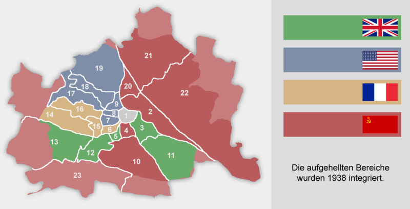
ဝှာင် လၟေင်အပြံင်အလှာဲ
ဍဵု လတူ စၟတ်တ္ၚဲ/အခိင် မွဲမွဲ သွက်ဂွံ ထ္ၜးကဵု ဝှာင် မကတဵုဒှ်လဝ် ပ္ဍဲအခိင်ဂှ်၊၊
| စၟတ်တ္ၚဲ/အခိင် | ဗီုပြင်နမူနာ | ပမာဏ | ညးလွပ် | တင်ပသောင်ကလး | |
|---|---|---|---|---|---|
| လၟုဟ် | ၂၁:၄၆၊ ၂၁ နဝ်ဝေမ်ဗါ ၂၀၁၈ | | ၁၄၀၀ × ၇၁၂ (၉၂ KB) | Hanzlan | Albern war bis 1954 Teil des sowjetisch besetzten Niederösterreich, daher hellrot umgefärbt, ebenso kleine Teile des 14. und 19. Bezirks. |
| ၁၇:၃၅၊ ၈ ဇာန်နဝါရဳ ၂၀၁၇ |  | ၁၄၀၀ × ၇၁၂ (၉၂ KB) | Foghe | Reverted to version as of 11:53, 16 March 2016 (UTC) Better colours (like the map of Austria) and biggest dimensions. | |
| ၂၀:၄၅၊ ၂၇ ဒဳဇြေမ်ဗါ ၂၀၁၆ |  | ၁၂၈၀ × ၆၅၁ (၁၉၈ KB) | Paasikivi | väri vahvistus colour strengthening | |
| ၁၈:၂၃၊ ၁၆ မာတ် ၂၀၁၆ |  | ၁၄၀၀ × ၇၁၂ (၉၂ KB) | Kontrollstellekundl | original flag colors | |
| ၂၂:၁၁၊ ၉ ဇာန်နဝါရဳ ၂၀၀၉ |  | ၁၄၀၀ × ၇၁၂ (၇၈ KB) | C.lingg | {{Information |Description=changed the "erste Bezirk" it was under control of all 4 countries |Source=myself |Date=09.01.2009 |Author=Christoph Lingg, ~~ |Permission={{cc-by-sa-2.0-de}} |other_versions= }} | |
| ၂၀:၁၃၊ ၁၄ သေပ်တေမ်ဗါ ၂၀၀၈ |  | ၁၄၀၀ × ၇၁၂ (၁၀၆ KB) | IJA | Vereinigtes Königreich ist das Grün. | |
| ၂၀:၁၂၊ ၁၄ သေပ်တေမ်ဗါ ၂၀၀၈ |  | ၁၄၀၀ × ၇၁၂ (၁၀၇ KB) | IJA | Vereinigtes Königreich ist das Grün. | |
| ၂၀:၃၀၊ ၁၄ အံက်တဝ်ဗါ ၂၀၀၇ |  | ၁၄၀၀ × ၇၁၂ (၇၈ KB) | C.lingg | fixed the amrican flag, it contains now 48 stars. {{Bild-CC-by-sa/2.0/de}})</nowiki>'' |Date= 2005-08-21 |Author= Christoph Lingg |Permission= {{cc-by-sa-2.0-de}} |other_versions= }} | |
| ၁၆:၄၄၊ ၃၀ အံက်တဝ်ဗါ ၂၀၀၅ |  | ၁၄၀၀ × ၇၁၂ (၇၈ KB) | Martg76~commonswiki | Author: Christoph Lingg Date: August 21, 2005 Source URL: [http://de.wikipedia.org/wiki/Bild:Wien_Besatzungszonen.png] |
ဝှာင် ဗီုဂွံစကာ
မုက်လိက် မရပ်စပ် ဝှာင်ဏအ် ဟွံမဲ၊၊
ဝှာင် သွက်ဂွံသုင်စောဲ ဂလုပ်ဗဴ
ဗွဲသၟဝ်ဏအ်ဂှ် ဒှ်အရာ ဝဳကဳတၞဟ် မစကာလဝ် ဝှာင်ဏအ်၊၊
- ဗီုစကာ ပ္ဍဲ ar.wikipedia.org
- ဗီုစကာ ပ္ဍဲ be-tarask.wikipedia.org
- ဗီုစကာ ပ္ဍဲ be.wikipedia.org
- ဗီုစကာ ပ္ဍဲ bn.wikipedia.org
- ဗီုစကာ ပ္ဍဲ bs.wikipedia.org
- ဗီုစကာ ပ္ဍဲ cs.wikipedia.org
- ဗီုစကာ ပ္ဍဲ da.wikipedia.org
- ဗီုစကာ ပ္ဍဲ de.wikipedia.org
- ဗီုစကာ ပ္ဍဲ el.wikipedia.org
- ဗီုစကာ ပ္ဍဲ en.wikipedia.org
- ဗီုစကာ ပ္ဍဲ es.wikipedia.org
- ဗီုစကာ ပ္ဍဲ et.wikipedia.org
- ဗီုစကာ ပ္ဍဲ fr.wikipedia.org
- ဗီုစကာ ပ္ဍဲ hr.wikipedia.org
- ဗီုစကာ ပ္ဍဲ hu.wikipedia.org
- ဗီုစကာ ပ္ဍဲ hy.wikipedia.org
- ဗီုစကာ ပ္ဍဲ hyw.wikipedia.org
- ဗီုစကာ ပ္ဍဲ io.wikipedia.org
- ဗီုစကာ ပ္ဍဲ is.wikipedia.org
- ဗီုစကာ ပ္ဍဲ it.wikipedia.org
- ဗီုစကာ ပ္ဍဲ ja.wikipedia.org
- ဗီုစကာ ပ္ဍဲ ka.wikipedia.org
- ဗီုစကာ ပ္ဍဲ ko.wikipedia.org
- ဗီုစကာ ပ္ဍဲ la.wikipedia.org
- ဗီုစကာ ပ္ဍဲ lb.wikipedia.org
- ဗီုစကာ ပ္ဍဲ mk.wikipedia.org
- ဗီုစကာ ပ္ဍဲ ms.wikipedia.org
- ဗီုစကာ ပ္ဍဲ nl.wikipedia.org
- ဗီုစကာ ပ္ဍဲ no.wikipedia.org
ဗဵု more global usage ဝှာင်ဏအ်၊၊