
ဝှာင်:WikiProject Asian Americans map.svg

Size of this PNG preview of this SVG file: ၅၇၄ × ၃၄၁ pixels. အရာမသ္ဂုတ်သွာတ်လဝ်ဂမၠိုၚ်: ၃၂၀ × ၁၉၀ pixels | ၆၄၀ × ၃၈၀ pixels | ၁၀၂၄ × ၆၀၈ pixels | ၁၂၈၀ × ၇၆၀ pixels | ၂၅၆၀ × ၁၅၂၁ pixels တၞဟ်။
ဝှာင် တမ်မူလ (SVG ဝှာင်, မိက်ကဵုကသပ် ၅၇၄ × ၃၄၁ pixels, ဇမၞော် ဝှာင်: ၁.၀၇ MB)
သကေမ်
| ကဵုယၟု |
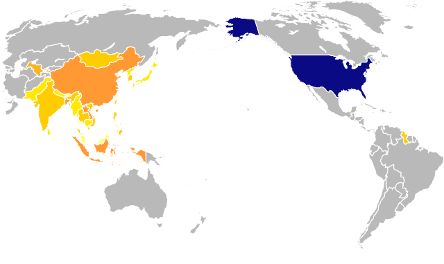
English: A map to be used in the identification of Wikipedia:WikiProject Asian Americans, highlighting both the United States and various areas associated with the Asian-American communities that are within the scope of the project. Highlighted in shades of orange: Bangladesh, Bhutan, Brunei Darussalam, Cambodia, China, Democratic People's Republic of Korea (North Korea), Guyana, Hong Kong, India, Indonesia, Jamaica, Japan, Lao People's Democratic Republic (Laos), Macao, Malaysia, Maldives, Mongolia, Myanmar, Nepal, Pakistan, Philippines, Republic of Korea (South Korea), Singapore, Sri Lanka, Taiwan, Province of China, Thailand, Timor-Leste (East Timor), Trinidad and Tobago, and Viet Nam. Highlighted in dark navy: American Samoa, Guam, Northern Marianas, Puerto Rico, United States of America, United States Minor Outlying Islands, and United States Virgin Islands. |
| စၟတ်တ္ၚဲ | |
| တမ်ရိုဟ် | |
| ကဝိ |
|
| SVG genesis | ဤ SVG ၏ ကုဒ်သည် ခိုင်လုံသည်။ |
မသ္ဂုတ်သွာတ်လာင်ဇြေန်
ကျွန်ုပ်၊ ဤလုပ်ဆောင်ချက်၏ မူပိုင်ခွင့်ပိုင်ရှင်အနေဖြင့် ဤနေရာမှ အောက်ပါလိုင်စင်အောက်တွင် ထုတ်လွှင့်ပါသည်:
| I, the copyright holder of this work, release this work into the public domain. This applies worldwide. In some countries this may not be legally possible; if so: အကျွန်ုပ်သည် ဤဖန်တီးမှုလက်ရာကို ဥပဒေအရလိုအပ်ခြင်းမရှိသည့် မည်သည့်အခြေအနေမျိုးတွက်မဆို၊ မည်သို့သော ရည်ရွယ်ချက်အတွက်မဆို ၎င်းကို မည်သူမဆို အသုံးပြုပိုင်ခွင့်အား ပေးအပ်သည်။ |
မူရင်းတင်ထားသောမှတ်တမ်း
This image is a derivative work of the following images:
- BlankMap-World-180E.svg licensed with PD-self
- 2008-04-13T22:24:07Z Lokal Profil 940x477 (3620359 Bytes) {{Information |Description=A blank map of the world centered at the 180E longitude line. Detailed SVG map with grouping enabled to connect all non-contiguous parts of a country's territory for easy colouring. Smaller count
Uploaded with derivativeFX
ဝှာင် လၟေင်အပြံင်အလှာဲ
ဍဵု လတူ စၟတ်တ္ၚဲ/အခိင် မွဲမွဲ သွက်ဂွံ ထ္ၜးကဵု ဝှာင် မကတဵုဒှ်လဝ် ပ္ဍဲအခိင်ဂှ်၊၊
| စၟတ်တ္ၚဲ/အခိင် | ဗီုပြင်နမူနာ | ပမာဏ | ညးလွပ် | တင်ပသောင်ကလး | |
|---|---|---|---|---|---|
| လၟုဟ် | ၀၃:၅၆၊ ၁၅ ဖေဖဝ်ဝါရဳ ၂၀၁၅ | | ၅၇၄ × ၃၄၁ (၁.၀၇ MB) | EuroCarGT | Updated per request at Wikipedia's Graphics Lab |
| ၀၃:၃၀၊ ၁၀ ဂျောန် ၂၀၁၁ |  | ၅၇၄ × ၃၄၁ (၉၆၇ KB) | MissMJ | Highlighting Maldives and East Timor. | |
| ၁၂:၁၈၊ ၈ ဂျောန် ၂၀၁၁ |  | ၅၇၅ × ၃၄၂ (၉၉၀ KB) | MissMJ | Highlighting more countries. | |
| ၀၂:၅၁၊ ၈ ဂျောန် ၂၀၁၁ |  | ၅၈၅ × ၃၄၅ (၁.၀၄ MB) | MissMJ | Removed black border. | |
| ၀၈:၃၈၊ ၇ ဂျောန် ၂၀၁၁ |  | ၅၈၅ × ၃၄၅ (၁.၀၄ MB) | MissMJ | Adding back the white background. | |
| ၀၈:၃၄၊ ၇ ဂျောန် ၂၀၁၁ |  | ၅၈၅ × ၃၄၅ (၁.၀၄ MB) | MissMJ | Removing extraneous shapes outside the visible area to reduce file size. | |
| ၀၈:၃၁၊ ၇ ဂျောန် ၂၀၁၁ |  | ၅၈၅ × ၃၄၅ (၂.၆၂ MB) | MissMJ | {{Information |Description=A map to be used in the identification of Wikipedia:WikiProject Asian Americans, highlighting both the United States and various areas associated with the Asian-American communities that are within the scope of the project. |
ဝှာင် ဗီုဂွံစကာ
မုက်လိက် မရပ်စပ် ဝှာင်ဏအ် ဟွံမဲ၊၊
ဝှာင် သွက်ဂွံသုင်စောဲ ဂလုပ်ဗဴ
ဗွဲသၟဝ်ဏအ်ဂှ် ဒှ်အရာ ဝဳကဳတၞဟ် မစကာလဝ် ဝှာင်ဏအ်၊၊
- ဗီုစကာ ပ္ဍဲ en.wikipedia.org
- Draft talk:Lily Tung Crystal
- Talk:First transcontinental railroad
- Internment of Japanese Americans
- Issei
- Sansei
- Chinese Americans
- Talk:Chinese Americans
- Talk:Chinese Exclusion Act
- Asian Americans
- Talk:Margaret Cho
- Talk:Asia Carrera
- Talk:Iva Toguri D'Aquino
- Talk:Kalpana Chawla
- Talk:Dinesh D'Souza
- Talk:Gish Jen
- Talk:Internment of Japanese Americans
- Korean Americans
- Talk:Executive Order 9066
- Talk:Chien-Shiung Wu
- Talk:Rosalind Chao
- Amerasian
- Talk:Amerasian
- Talk:Maxine Hong Kingston
- Talk:Elaine Chao
- Talk:Fortune cookie
- Talk:Jook-sing
- Taiwanese Americans
- Talk:Yo-Yo Ma
- Talk:Taiwanese Americans
- Asian American Journalists Association
- User talk:Ishu
- Talk:Manzanar
- Talk:Asian Americans
- Talk:List of Japanese Americans
- Talk:Chinatown–International District, Seattle
- Talk:American-born Chinese
- Talk:Gayatri Chakravorty Spivak
- Vietnamese Americans
- Talk:Vietnamese Americans
- Talk:American Chinese cuisine
- Laotian Americans
- Talk:Japanese Americans
- Talk:List of Chinese Americans
- Talk:Vera Wang
- Talk:Soy sauce
- Talk:Deepak Chopra
- Talk:Korematsu v. United States
- Talk:99 Ranch Market
- Talk:Bruce Lee
- Talk:Chinatown, Manhattan
ဗဵု more global usage ဝှာင်ဏအ်၊၊