
ဝှာင်:Island of Ireland location map Down.svg

Size of this PNG preview of this SVG file: ၇၉၆ × ၅၉၉ pixels. အရာမသ္ဂုတ်သွာတ်လဝ်ဂမၠိုၚ်: ၃၁၉ × ၂၄၀ pixels | ၆၃၈ × ၄၈၀ pixels | ၁၀၂၀ × ၇၆၈ pixels | ၁၂၈၀ × ၉၆၄ pixels | ၂၅၆၀ × ၁၉၂၈ pixels | ၉၃၁ × ၇၀၁ pixels တၞဟ်။
ဝှာင် တမ်မူလ (SVG ဝှာင်, မိက်ကဵုကသပ် ၉၃၁ × ၇၀၁ pixels, ဇမၞော် ဝှာင်: ၈၂၆ KB)
| ကဵုယၟု |
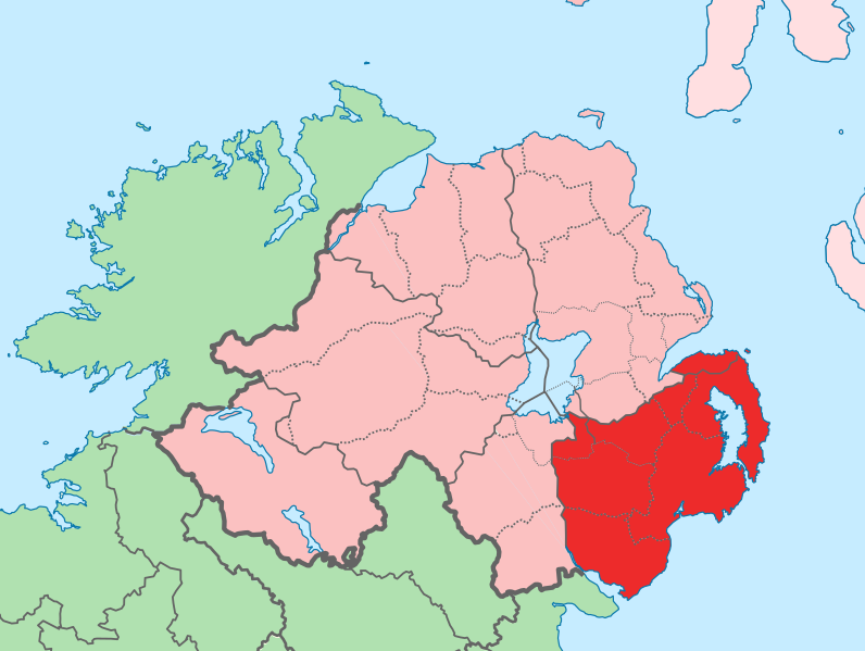
English: The island of Ireland, showing international border between Ireland and Northern Ireland, traditional provinces, traditional counties, and local authority areas in Ireland and Northern Ireland. |
| စၟတ်တ္ၚဲ | (UTC) |
| တမ်ရိုဟ် | |
| ကဝိ |
|
| This is a retouched picture, which means that it has been digitally altered from its original version. Modifications: Added colours for specific county. The original can be viewed here: Island of Ireland location map.svg:
|
ကျွန်ုပ်၊ ဤလုပ်ဆောင်ချက်၏ မူပိုင်ခွင့်ပိုင်ရှင်အနေဖြင့် ဤနေရာမှ အောက်ပါလိုင်စင်အောက်တွင် ထုတ်လွှင့်ပါသည်:
ဝှာင်ဏအ်ဂှ် စၟတ်သမ္တီလဝ် နကဵုလာင်ဇြေန် Creative Commons Attribution-Share Alike 3.0 Unported ရ၊၊
- မၞးဂှ် ဗွဲမဗၠးၜး -
- သွက်ဂွံ ပါ်ပရအ် – သွက်ဂွံ စၠောအ်ပပ်ပဳ၊ တြးပတိတ်၊ ဗလး ကမၠောန်
- သွက်ဂွံ ပကောံနှဴ – သွက်ဂွံ ပလေဝ်ပညဳ ကမၠောန်
- နကဵု တင်မသ္ဒးဒ္ဂေတ်ဗက် ဗွဲသၟဝ်ဏအ်ဂှ်
- တင်မစှ်ေစိုတ် – မၞး သ္ဒးဒ္ဂေတ်ဗက် သၞောတ်ဝ် မဖျေဟ်လဝ် စပ်ကဵု အစာချူလိက် ဟွံသေင်မ္ဂး တၠမူတအ်ရောင်၊၊ (ဆဂး နကဵုနဲလဵု အကာဲအရာ ဗီုလဵုလေဝ် ဟွံကဵုကသပ် ဟွံထံက်ဂလာန် ကုမၞး ပ္ဍဲအရာမစကာ ဒြပ်ညးတၞဟ်တအ်ရောင်)။
- ပါ်ပရအ် အရာမတုပ်သၟဟ် – ယဝ်ရ မၞး ပလေဝ်၊ ပြံင်လှာဲ ဟွံသေင်မ္ဂး ထပ်ခၞံဗဒှ်တၟိမ္ဂး အရာကမၠောန်တအ် သီုဖအိုတ်ဂှ် သ္ဒးပရးပတိတ် နကဵုသၟဝ် မတုပ် ဟွံသေင်မ္ဂး မသၟဟ် ကုလာင်ဇြေန် ကမၠောန်တြေံဂှ် ဟေင်ရ၊၊
မူရင်းတင်ထားသောမှတ်တမ်း
This image is a derivative work of the following images:
- File:Island_of_Ireland_location_map.svg licensed with Cc-by-sa-3.0
- 2010-03-06T20:43:33Z Rannpháirtí anaithnid 1450x1807 (679207 Bytes) Fix incorrectly coloured isands.
- 2010-03-03T22:19:29Z Rannpháirtí anaithnid 1450x1807 (679744 Bytes) {{Information |Description={{de|Positionskarte von [[:de:Irland|Irland]]}} Quadratische Plattkarte, N-S-Streckung 170 %. Geographische Begrenzung der Karte: * N: 55.6° N * S: 51.2° N * W: 11.0° W * O: 5.0° W {{en|Location
Uploaded with derivativeFX
ဝှာင် လၟေင်အပြံင်အလှာဲ
ဍဵု လတူ စၟတ်တ္ၚဲ/အခိင် မွဲမွဲ သွက်ဂွံ ထ္ၜးကဵု ဝှာင် မကတဵုဒှ်လဝ် ပ္ဍဲအခိင်ဂှ်၊၊
| စၟတ်တ္ၚဲ/အခိင် | ဗီုပြင်နမူနာ | ပမာဏ | ညးလွပ် | တင်ပသောင်ကလး | |
|---|---|---|---|---|---|
| လၟုဟ် | ၁၉:၃၂၊ ၁၉ ဂျူလာင် ၂၀၁၀ | | ၉၃၁ × ၇၀၁ (၈၂၆ KB) | Mabuska | fixed scotland boundary |
| ၁၈:၁၅၊ ၁၉ ဂျူလာင် ၂၀၁၀ |  | ၉၃၄ × ၇၁၇ (၈၂၈ KB) | Mabuska | {{Information |Description={{en|The island of Ireland, showing international border between Northern Ireland and Republic of Ireland, traditional provinces, traditional counties, and local authority areas in the Republic of Ireland and Northern Ireland.}} |
ဝှာင် ဗီုဂွံစကာ
မုက်လိက် မရပ်စပ် ဝှာင်ဏအ် ဟွံမဲ၊၊
ဝှာင် သွက်ဂွံသုင်စောဲ ဂလုပ်ဗဴ
ဗွဲသၟဝ်ဏအ်ဂှ် ဒှ်အရာ ဝဳကဳတၞဟ် မစကာလဝ် ဝှာင်ဏအ်၊၊
- ဗီုစကာ ပ္ဍဲ ar.wikipedia.org
- ဗီုစကာ ပ္ဍဲ ast.wikipedia.org
- ဗီုစကာ ပ္ဍဲ bg.wikipedia.org
- ဗီုစကာ ပ္ဍဲ ca.wikipedia.org
- ဗီုစကာ ပ္ဍဲ cs.wikipedia.org
- ဗီုစကာ ပ္ဍဲ de.wikipedia.org
- ဗီုစကာ ပ္ဍဲ en.wikipedia.org
- ဗီုစကာ ပ္ဍဲ eo.wikipedia.org
- ဗီုစကာ ပ္ဍဲ es.wikipedia.org
- ဗီုစကာ ပ္ဍဲ eu.wikipedia.org
- Belfast
- Newry
- Lisburn
- Bangor (Ipar Irlanda)
- Downpatrick
- Lankide:Euskaldunaa
- Newtownards
- Banbridge
- Down konderria
- Txantiloi:Down konderriko udalerriak
- Lurganville
- Ballynahinch (Down konderria)
- Carryduff
- Comber
- Donaghadee
- Dromore (Down konderria)
- Dundonald
- Holywood
- Kilkeel
- Newcastle (Down konderria)
- Warrenpoint
- Annahilt
- Annalong
- Annsborough
- Ardglass
- Atticall
- Aughnacloy (Down konderria)
- Ballela
- Balloo (Down konderria)
- Ballybannan
- Ballybeen
- Ballydargan
- Ballygowan
- Ballyhalbert
- Ballyhay
- Ballyhornan
- Ballykinler
- Ballylesson
- Ballylough
- Ballymacmaine
ဗဵု more global usage ဝှာင်ဏအ်၊၊