
ဝှာင်:Europe location SCO2.png

ဇမၞော် နမူနာ ဏအ် - ၈၀၀ × ၅၉၉ pixels အရာမသ္ဂုတ်သွာတ်လဝ်ဂမၠိုၚ်: ၃၂၀ × ၂၄၀ pixels | ၆၄၀ × ၄၇၉ pixels | ၁၀၂၄ × ၇၆၇ pixels | ၁၂၈၀ × ၉၅၉ pixels | ၁၅၉၄ × ၁၁၉၄ pixels တၞဟ်။
ဝှာင် တမ်မူလ (၁၅၉၄ × ၁၁၉၄ pixels, file size: ၅၅၈ KB, MIME type: image/png)
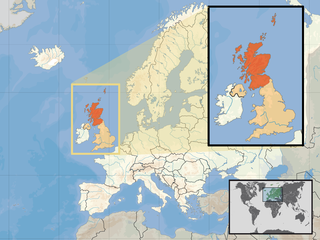
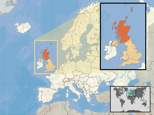
| ကဵုယၟု | Location of Scotland in the UK and Europe, on terrain map showing surface and underwater contour areas. | |||
| စၟတ်တ္ၚဲ | ||||
| တမ်ရိုဟ် | Derived from Wikimedia Commons image of original work forming part of the "Europe location" map series created by David Liuzzo: derived from Image:Europe_location_SCO.png. | |||
| ကဝိ | uploaded by User:Kmusser (excerpt from User:David_Liuzzo) | |||
| တင်မကဵုအခေါင် (ကလေင်သုင်စောဲ ဝှာင်ဏအ်) |
|
|||
| အခြား ဗားရှင်းများ |
|


ဝှာင် လၟေင်အပြံင်အလှာဲ
ဍဵု လတူ စၟတ်တ္ၚဲ/အခိင် မွဲမွဲ သွက်ဂွံ ထ္ၜးကဵု ဝှာင် မကတဵုဒှ်လဝ် ပ္ဍဲအခိင်ဂှ်၊၊
| စၟတ်တ္ၚဲ/အခိင် | ဗီုပြင်နမူနာ | ပမာဏ | ညးလွပ် | တင်ပသောင်ကလး | |
|---|---|---|---|---|---|
| လၟုဟ် | ၁၉:၀၉၊ ၁၀ ဨပြဳ ၂၀၁၇ | | ၁၅၉၄ × ၁၁၉၄ (၅၅၈ KB) | Von Sprat | Reverted to version as of 12:25, 27 May 2010 (UTC) |
| ၁၉:၀၉၊ ၁၀ ဨပြဳ ၂၀၁၇ |  | ၁၆၀၀ × ၁၂၀၀ (၇၈၈ KB) | Von Sprat | greece/turkey border | |
| ၁၈:၅၅၊ ၂၇ မေ ၂၀၁၀ |  | ၁၅၉၄ × ၁၁၉၄ (၅၅၈ KB) | Ras67 | cropped | |
| ၀၀:၀၁၊ ၃၀ သေပ်တေမ်ဗါ ၂၀၀၈ |  | ၁၆၀၀ × ၁၂၀၀ (၇၆၇ KB) | Kmusser | re-cropped inset to include Shetlands | |
| ၂၃:၅၂၊ ၂၉ သေပ်တေမ်ဗါ ၂၀၀၈ |  | ၁၆၀၀ × ၁၂၀၀ (၈၀၇ KB) | Kmusser | {{Information |Description= Location of Scotland in the UK and Europe, on terrain map showing surface and underwater contour areas. |Source=Derived from Wikimedia Commons image of original work forming part of the "Europe location" map series |
ဝှာင် ဗီုဂွံစကာ
အရာမဆက်ဗက်ကၠုင် page links ကုဝှာင်ဏအ် ဂမၠိုင်ဂှ် -
ဝှာင် သွက်ဂွံသုင်စောဲ ဂလုပ်ဗဴ
ဗွဲသၟဝ်ဏအ်ဂှ် ဒှ်အရာ ဝဳကဳတၞဟ် မစကာလဝ် ဝှာင်ဏအ်၊၊
- ဗီုစကာ ပ္ဍဲ als.wikipedia.org
- ဗီုစကာ ပ္ဍဲ an.wikipedia.org
- ဗီုစကာ ပ္ဍဲ az.wiktionary.org
- ဗီုစကာ ပ္ဍဲ ca.wikipedia.org
- ဗီုစကာ ပ္ဍဲ da.wikipedia.org
- ဗီုစကာ ပ္ဍဲ en.wikipedia.org
- ဗီုစကာ ပ္ဍဲ es.wikipedia.org
- ဗီုစကာ ပ္ဍဲ eu.wiktionary.org
- ဗီုစကာ ပ္ဍဲ ext.wikipedia.org
- ဗီုစကာ ပ္ဍဲ fiu-vro.wikipedia.org
- ဗီုစကာ ပ္ဍဲ fr.wikinews.org
- ဗီုစကာ ပ္ဍဲ gag.wikipedia.org
- ဗီုစကာ ပ္ဍဲ gl.wikipedia.org
- ဗီုစကာ ပ္ဍဲ hr.wikipedia.org
- ဗီုစကာ ပ္ဍဲ hr.wikiquote.org
- ဗီုစကာ ပ္ဍဲ kn.wikipedia.org
- ဗီုစကာ ပ္ဍဲ krc.wikipedia.org
- ဗီုစကာ ပ္ဍဲ ml.wikipedia.org
- ဗီုစကာ ပ္ဍဲ mr.wikipedia.org
- ဗီုစကာ ပ္ဍဲ my.wikipedia.org
- ဗီုစကာ ပ္ဍဲ nov.wikipedia.org
- ဗီုစကာ ပ္ဍဲ no.wikipedia.org
- ဗီုစကာ ပ္ဍဲ pl.wikipedia.org
- ဗီုစကာ ပ္ဍဲ pl.wikivoyage.org
- ဗီုစကာ ပ္ဍဲ pl.wiktionary.org
- ဗီုစကာ ပ္ဍဲ su.wikipedia.org
- ဗီုစကာ ပ္ဍဲ sv.wikivoyage.org
- ဗီုစကာ ပ္ဍဲ te.wikipedia.org
- ဗီုစကာ ပ္ဍဲ tr.wikipedia.org
- ဗီုစကာ ပ္ဍဲ ug.wikipedia.org
- ဗီုစကာ ပ္ဍဲ vls.wikipedia.org
- ဗီုစကာ ပ္ဍဲ yo.wikipedia.org